My mother was murdered by what I call corporate and political homicide i.e. FOR PROFIT! she died from a rare phenotype of CJD i.e. the Heidenhain Variant of Creutzfeldt Jakob Disease i.e. sporadic, simply meaning from unknown route and source. I have simply been trying to validate her death DOD 12/14/97 with the truth. There is a route, and there is a source. There are many here in the USA. WE must make CJD and all human TSE, of all age groups 'reportable' Nationally and Internationally, with a written CJD questionnaire asking real questions pertaining to route and source of this agent. Friendly fire has the potential to play a huge role in the continued transmission of this agent via the medical, dental, and surgical arena. We must not flounder any longer. ...TSS
Deepwater Horizon crude oil impacts the developing hearts of large
predatory pelagic fish
John P. Incardonaa,1, Luke D. Gardnerb, Tiffany L. Linboa, Tanya L. Browna,
Andrew J. Esbaughc, Edward M. Magerc, John D. Stieglitzc, Barbara L. Frencha,
Jana S. Labeniaa, Cathy A. Laetza, Mark Tagala, Catherine A. Sloana, Abigail
Elizurd, Daniel D. Benettic, Martin Grosellc, Barbara A. Blockb, and Nathaniel
L. Scholza
Author Affiliations
Edited by Karen A. Kidd, University of New Brunwsick, Saint John, BC,
Canada, and accepted by the Editorial Board February 24, 2014 (received for
review November 6, 2013)
Significance The 2010 Deepwater Horizon (MC252) disaster in the northern
Gulf of Mexico released more than 4 million barrels of crude oil. Oil rose from
the ocean floor to the surface where many large pelagic fish spawn. Here we
describe the impacts of field-collected oil samples on the rapidly developing
embryos of warm-water predators, including bluefin and yellowfin tunas and an
amberjack. For each species, environmentally relevant MC252 oil exposures caused
serious defects in heart development. Moreover, abnormalities in cardiac
function were highly consistent, indicating a broadly conserved developmental
crude oil cardiotoxicity. Losses of early life stages were therefore likely for
Gulf populations of tunas, amberjack, swordfish, billfish, and other large
predators that spawned in oiled surface habitats.
The Deepwater Horizon disaster released more than 636 million L of crude
oil into the northern Gulf of Mexico. The spill oiled upper surface water
spawning habitats for many commercially and ecologically important pelagic fish
species. Consequently, the developing spawn (embryos and larvae) of tunas,
swordfish, and other large predators were potentially exposed to crude
oil-derived polycyclic aromatic hydrocarbons (PAHs). Fish embryos are generally
very sensitive to PAH-induced cardiotoxicity, and adverse changes in heart
physiology and morphology can cause both acute and delayed mortality. Cardiac
function is particularly important for fast-swimming pelagic predators with high
aerobic demand. Offspring for these species develop rapidly at relatively high
temperatures, and their vulnerability to crude oil toxicity is unknown. We
assessed the impacts of field-collected Deepwater Horizon (MC252) oil samples on
embryos of three pelagic fish: bluefin tuna, yellowfin tuna, and an amberjack.
We show that environmentally realistic exposures (1–15 μg/L total PAH) cause
specific dosedependent defects in cardiac function in all three species, with
circulatory disruption culminating in pericardial edema and other secondary
malformations. Each species displayed an irregular atrial arrhythmia following
oil exposure, indicating a highly conserved response to oil toxicity. A
considerable portion of Gulf water samples collected during the spill had PAH
concentrations exceeding toxicity thresholds observed here, indicating the
potential for losses of pelagic fish larvae. Vulnerability assessments in other
ocean habitats, including the Arctic, should focus on the developing heart of
resident fish species as an exceptionally sensitive and consistent indicator of
crude oil impacts.
snip...
In conjunction with previous studies, the findings here demonstrate that
the response of teleost embryos to petroleumderived PAHs in both the laboratory
and the field is highly conserved among species tested thus far. Tunas and
amberjacks develop at higher water temperatures, and yet they display heart
failure and other abnormalities that are remarkably similar to those previously
reported for species, such as herring and salmon, which develop at very cold
temperatures. Pacific herring were a focal species for natural resource injury
assessments following the Exxon Valdez (41) (Alaskan waters) and Cosco Busan oil
spills (38) (California Current). Herring early life stages exposed to both oil
types, in both the field and the laboratory, developed cardiotoxic defects in
the form of bradycardia (38) and pericardial edema (38, 41), with strikingly
similar results to those reported here for subtropical spawning pelagic fish.
The remarkably consistent morphological and physiological responses to oil
across diverse fish species indicate that the core mechanisms of PAH-induced
cardiotoxicity are conserved. Namely, the cardiotoxic injury stemming from
embryonic exposure to crude oil observed in the scombrid and carangid species in
this study is essentially identical to the response of a boreal clupeid
(herring) (19), representing families that are separated by roughly 100 million
y of evolution (42).
***Our findings thus have implications beyond the upper pelagic zone of the
Gulf of Mexico, and are likely to be indicative of sensitivity to oil over a
wider range of fish species spawning in other habitats contaminated by MC252
crude oil.
While Galveston Bay is an outstanding place to fish, you need to be aware of seafood consumption advisories!
The Texas Department of State Health Services (DSHS) issues seafood consumption advisories when tests on fish and shellfish indicate there is an increased risk to human health from the presence of toxic pollutants.
This map shows the seafood consumption advisories that are currently in place in the Galveston Bay system and its tributaries. There are really four areas, each having its own set of affected species.
Species Affected, and DSHS Advisories in Each Area of Concern
Area
Species Affected
Pollutants
DSHS Advisory Number and Year Issued
The Houston Ship Channel and all contiguous waters north of the Fred Hartman Bridge (Hwy. 146), including the San Jacinto River below the Lake Houston Dam.
Galveston Bay system south of a line from Red Bluff Point to Five Mile Cut Marker to Houston Point, including Chocolate Bay, East Bay, West Bay, Trinity Bay, and contiguous waters.
Consumption Advice You Should Follow for All Areas Except Clear Creek
In each of these three areas for the species listed, the following advice should be followed to decrease risks to human health:
Women of childbearing age and children under the age of 12 - DO NOT EAT ANY AMOUNT OF THE SPECIES LISTED!
Women past childbearning age and adult men - DO NOT EAT MORE THAN 8 OUNCES PER MONTH OF THE SPECIES LISTED!
Consumption Advice You Should Follow for Clear Creek Upstream of Clear Lake
All persons - DO NOT EAT ANY AMOUNT OF ANY SPECIES OF FISH!
Why Is There a Risk from Consuming the Species Listed in These Areas?
When fish and crab eat, they accumulate toxic pollutants present in the prey they consume or in tainted sediment or water they filter. This process is called bioaccumulation. These toxic materials - such as organochlorine pesticides, dioxins and polychlorinated biphenyls (PCBs) - are in the environment as a result of rainfall runoff from land, spills, leaks, and improper disposal of industrial wastes.
These pollutants can especially accumulate in the fatty areas, glands, and organs of fish and crabs. As a result, some species of fish that have higher fat content - such as spotted seatrout and catfish - are listed for the advisories while others - such as red drum, black drum, croaker, and flounder - are not. However, in areas of heavy industry such as above the Lynchburg Ferry, all species of fish and blue crabs may have higher concentrations.
Exposure to organochlorine pesticides, dioxins and PCBs can cause a range of illness from skin rashes to immune system and nerve disorders to liver damage and increased risk of cancer. These toxins also pose a risk of birth defects and the development of children. The Agency for Toxic Substances & Disease Registry has more information on dioxins and PCBs.
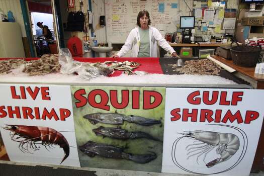
What about Shrimp, Oysters and Clams?
There are no DSHS seafood consumption advisories on shrimp, oysters, or clams. However, the harvest of molluscan shellfish (oysters, clams, and mussels) is illegal in DSHS designated “Prohibited Areas” that are in proximity to sewage treatment plant discharge locations, known contaminated areas, or other area with a high potential of containing unsafe levels of a pollutant. For example, the Houston Ship Channel/San Jacinto River upstream of Morgan’s Point is a prohibited molluscan shellfish harvest area. You can find more information and maps on the DSHS Shellfish Harvest Classification webpage.
How You Can Reduce Your Risk from These Toxins
You should do your best to follow the advisory recommendations for consumption of the species listed in these areas. Instead of eating the same type of fish from the same waterbodies, you should fish for different species from a variety of waterbodies. You should eat smaller, younger fish that have less time to accumulate toxins in their bodies. Last, if you clean and cook the fish or crabs so that you avoid eating their fatty portions, you can reduce your risk.
The Houston-Galveston Area Council's Seafood Caution brochure has more information on the toxins and how you can prepare your catch so that your risk is decreased. DSHS has detailed information on each of these advisories. Click on the following links for PDF versions of each advisory:
These advisories and much more information such as detailed maps, risk characterization studies, and Frequently Asked Questions can be found on the DSHS Seafood and Aquatic Life Group webpage. Just click on "Fish Consumption Advisory" on the left-hand side of the page.
Galveston Bay Oil Spill and the IKE dike VS Rice dike
Greetings neighbors and friends of our Bayshore fishing community we all so
love, and everyone around Galveston Bay.
First off, I want to say to the Hillman Family, and everyone that there
livelihood and recreation and love for Galveston Bay have been affected by this
damn oil spill, we can’t imagine your pain, and support you in the coming
fight.
this Galveston Bay oil spill gives much credence to a speedy confirmation
of the IKE...IKE...IKE Dike, over the rice dike. for obvious reasons.
you damn up the north end of Galveston bay, and you only protect the
industry, and they will pay nothing for this protection. the rest of us around
Galveston Bay will flounder when the next big one comes.
you damn up the south end of Galveston bay, just this side of the Y, and or
at the coast, you can close off the bay to the spill. you protect all of
Galveston Bay, not just the fat cats.
of course, if you move the dangerous chemicals and petroleum products to
the port of Galveston, and or offshore floating port, .........never mind, that
will never happen, just dreaming.
Monday, November 18, 2013
Is your community just collateral damage? RICE DIKE VS IKE DIKE
we want to be sure to thank all the responders, US Coast Guard, and all the
Volunteers, that helped and are still helping, clean up this mess, and help save the birds and
fish and the Bay and the Gulf of Mexico. ...THANK YOU!
Published On: Mar 31 2014 06:16:25 PM CDTUpdated On: Mar 31 2014 10:32:07 PM CDT
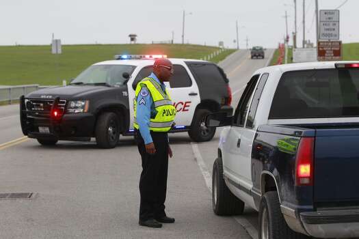
Texas oil spill: Recorded moments before impact
ONE WEEK AFTER THE SHIP CHANNEL COLLISION THAT CAUSED A OIL SPILL, WE ARE HEARING THE CONVERSATION THAT LED UP TO THAT IMPACT. IT'S A RECORDING YOU'LL HEAR ONLY ON 2 TONIGHT. "LOCAL 2" INVESTIGATOR JOEL EISENBAUM HAS MORE. Reporter: NSA. WELL, YOU KEEP ON GOING, I'M GOG GET YOU. Reporter: IT'S THE AUDIO TAPE FEDERAL INVESTIGATORS ARE POURING OVER AND "LOCAL 2" INVESTIGATES MANAGED TO OBTAIN A COPY. THE CAPTAIN TO CAPTAIN CONVERSATION, MINUTES BEFORE THE DISASTEROUS SHIP CHANNEL COLLISION MARCH 22. 'CAUSE RIGHT NOW I'M LESS THAN THREE QUARTER OF A MILE FROM YOU AND YOU AIN'T GOT TO THE CHANNEL YET. Reporter: THAT'S THE CARGO SHIP CAPTAIN WARNING THE TUG BOAT CAPTAIN HIS DECISION TO CROSS IN FRONT OF THEM WITH BARGES IS A POOR ONE. THERE WAS COMMUNICATION BETWEEN THOSE TWO VESSELS. WAS IT EARLY IN THE SITUATION? NO. Reporter: OUT OF THIS NEW FANCY BUILDING AT ELLINGTON, THE COAST GUARD RUN HAS VESSEL TRAFFIC SERVICE. ONLY THE DAY OF THE ACCIDENT, THE INFORMATION OFFICER DIDN'T WARN EITHER CAPTAIN ABOUT THEIR COLLISION COURSE. EVERY DAY, EVERY DAY ON THE HOUSTON SHIP CHANNEL, WE HAVE SHIPS MEETING IN A 530-FOOT WIDE CHANNEL AND TOW BOATS CROSSING AND THIS IS THE NORM. Reporter: HIS EMPLOYEES AREN'T LIKE AIR TRAFFIC CONTROLLERS. VESSEL CAPTAINS ARE THE ONES RESPONSIBLE FOR SETTING THEIR OWN COURSES AND AVOIDING EACH OTHER AND USUALLY IT WORKS. DON'T LOOK GOOD. YEAH, IT DON'T LOOK GOOD. YOU NEED TO KEEP ON BACKING IT DOWN AS HARD AS YOU CAN. I'M GOING TO SHOOT IT FOR THE RED SIDE. KEEP HER GOING. JOEL EISENBAUM, "LOCAL 2". REGARDLESS OF HOW THE FEDERAL INVESTIGATION ENDS, TEXAS LAW CONSIDERS THE COMPANY CARRYING THE OIL A RESPONSIBLE PARTY. THAT WOULD BE KIRBY AND IN REIN.
GALVESTON, Texas -
Local 2 Investigates has obtained the "captain to captain" conversation that took place via two-way radio just before the ship channel collision March 22.
"If you keep on coming, I'm going to get you," the Captain of the M/V Summer Wind, a cargo ship told the Captain of the T/V Miss Susan, a tugboat.
At that point, the Summer Wind was 3/4 mile from the Miss Susan. It appears to be the first conversation between the captains. Their vessles would collide approximately five minutes later.
Federal investigators have not yet assigned blame in the accident that dumped 168,000 gallons of oil into the Ship Channel water.
The tugboat was crossing the the Houston Ship Channel waterway occupied by the Summer Wind when the collision occurred.
"Right now I'm less than a 3/4 mile from you and you ain't even got to the Channel yet," The Summer Wind captain said.
Both captains appear to acknowledge they are on a collision course once the communication starts.
"There is communication. Was it early? No," Steven Nerheim, Director of the USCG Vessel Traffic Service of Houston/Galveston, said.
Nerhaim's team advises vessel captains in real time about traffic and weather conditions in and around the ship channel.
The operator working the day of the accident did not advise either captain about the collision course.
"We are not nearly the same thing as air traffic controllers," Nerheim said.
The duty to plot courses, and the responsibility to avoid collisions rests with vessel captains, Nerheim said.
This is the official site for the Texas City "Y" Response, hosting news releases and other response information. The most recent images and video from the response are updated on the Defense Video and Imagery Distribution System (DVIDShub.net)
Update 11: Reponse efforts continue on South Matagorda Island, Mustand island and Padre Island National Seashore
PORT O’CONNOR, Texas — More than 465 response contractors continued work today along the shores of Mustang and South Matagorda Islands and Padre Island National Seashore, employing conventional clean-up methods with rakes, shovels and buckets. A 9-mile stretch of shoreline along Matagorda Island is a primary emphasis of these crews today.
“Federal and state wildlife agencies continue to be focused on protecting these sensitive areas for the benefit of wildlife and are working closely to coordinate with our partners in the cleanup operations,” said Nancy Brown, Public Outreach Specialist for the U.S. Fish and Wildlife. “Everyone’s goal in this effort is to ensure these beaches are restored and healthy for the diversity of the wildlife that depends upon them.”
As of sunset on Wednesday, the Unified Command report that a total of 119,350 pounds of oiled sand and oiled debris has been removed from island shorelines, including 28,525 pounds that was removed yesterday.
Updates from federal and state wildlife agencies active in the field show that 77 deceased birds have now been recovered from Padre Island, Matagorda Island and Mustang Island. These include a variety of water fowl and shore birds. Additionally, two deceased dolphins have been recovered along with two deceased fresh water turtles.
It is unclear whether these deaths are directly related to the oil. Tests to make that determination will take several weeks. Throughout the day wildlife experts from Texas Parks and Wildlife and U.S. Fish and Wildlife were also engaged in monitoring Whooping Crane and other endangered species habitats. There are no reports of impacts on these species.
Persons who observe any impacted wildlife should not attempt to capture or handle them but are urged to call 888-384-2000.
Residents, tourists and others who may observe tar balls are urged to refrain from attempting their own clean-up activities and are asked to call 361-939-6349 to report the exact locations of any sightings. Persons who may be physically impacted by the oil should take quick action to wash the affected area with soap and warm water. The public is discouraged from accessing Matagorda Island until the Unified Command announces that response operations are complete.
Calhoun County residents will have an opportunity to engage members of the Unified Command at an informational session to take place on Thursday, April 3, at the Port O’Connor Elementary School, 508 Monroe Avenue. The session will take place at 6:30 p.m.
County and city officials, their Emergency Management Coordinators, and port officials and state agencies continued to exchange information through daily stakeholder telephone briefings.
The Kirby Inland Marine claims line continues to be available to persons who may have questions regarding personal impacts from the incident. The number is 855-276-1275. Please note that a previously published number is no longer operational.
For more information, contact the Matagorda Bay joint information center at 214-225-8007, or visit www.texascityYresponse.com.
###
For more information contact:
Matagorda Response JIC Texas City "Y" Response Area Command (214) 225-8007 3674 W. Adams St. Port O'Connor, TX 77982 TexasCityYResponse@gmail.com
Update 10: Response efforts continue on Matagorda Island and Padre Island National Seashore
A crew member displays a clump of tar recovered during clean-up operations at the beaches of National Seashore Park April 2, 2014. Local, state and federal agencies are working together to remove any materials containing oil that may have washed up ashore. U.S. Coast Guard photo by Petty Officer 3rd Class Carlos Vega.
Crew members work to remove oil and reduce impact to the beaches of National Seashore Park April 2, 2014. Local, state and federal agencies are working together to remove any materials containing oil that may have washed up ashore. U.S. Coast Guard photo by Petty Officer 3rd Class Carlos Vega.
PORT O’CONNOR, Texas — Crews responding to the March 22 oil spill in southeast Texas made new progress along the shores of south Matagorda and Mustang Islands and at Padre Island National Seashore (PINS) on Wednesday, despite high tides that limited work in some areas.
From supply and personnel staging areas in Port O’Connor and at Mustang Island, approximately 300 workers continued removing oiled debris and oiled sand using conventional tools such as rakes, shovels and buckets. Crews on PINS were able to facilitate their progress with small tractors as well.
The work of these field response teams is supported by approximately 115 other personnel at the Incident Command post at Port O’Connor, Texas. Thirty public and non-profit agencies are working in a coordinated effort under the leadership of the United States Coast Guard and Texas General Land Office to contain and recover the remnants of 168,000 gallons of oil that was spilled from a damaged barge in the Houston Ship Channel.
Residents, tourists and others who may observe tar balls are urged to refrain from attempting their own clean-up activities and are asked to call 361-939-6349 to report the exact locations of any sightings. Persons who may be physically impacted by the oil should take quick action to wash the affected area with soap and warm water. The public is discouraged from accessing Matagorda Island until the Unified Command announces that response operations are complete.
While oil recovery work on the water has been suspended, reconnaissance continues further south all the way to Brownsville, Texas. More than 225 miles of Texas coastline is being monitored for any potential impact.
Throughout the day wildlife experts from Texas Parks and Wildlife and U.S. Fish and Wildlife continued to monitor the status of wildlife including Whooping Cranes and other endangered species. To date there are no reports of impacts on these species, and updated statistics on any other wildlife impacts were not available as of 4 p.m. today.
Persons who observe any impacted wildlife should not attempt to capture or handle them but are urged to call 888-384-2000.
Calhoun County residents will have an opportunity to engage members of the Unified Command at an informational session to take place on Thursday, April 3, at the Port O’Connor Elementary School, 508 Monroe Avenue.
County and city officials, their Emergency Management Coordinators, and port officials and state agencies continued to exchange information daily through stakeholder telephone briefings.
A claims line has been established for persons who may have questions regarding personal impacts from the incident. The number is 855-276-1275. Please note that a previously published number is no longer operational.
For more information, contact the Matagorda Bay joint information center at 214-225-8007, or visit www.texascityYresponse.com.
###
For more information contact:
Matagorda Response JIC Texas City "Y" Response Area Command (214) 225-8007 3674 W. Adams St. Port O'Connor, TX 77982 TexasCityYResponse@gmail.com
Oil Spill Unified Command Will Participate in Community Sponsored Information Session
PORT O'CONNOR, Texas — Representatives of the Unified Command responding to a March 22 oil spill will join community leaders in an informational session on Thursday, April 3, at 6:30 p.m.
The event will take place at Port O’Connor Elementary School, 508 Monroe Avenue.
Officials from the United States Coast Guard, Texas General Land Office, Kirby Inland Marine, Texas Parks and Wildlife, U.S. Fish and Wildlife, NOAA, and Texas Department of Health Services will join representatives from Calhoun County government and the Chamber of Commerce in updating the community.
“We are pleased to be invited to meet with local residents and business owners and appreciate the opportunity to answer any questions or concerns they may have,” said Incident Commander Randal S. Ogryzdiak.
Persons interested in the claims process nay call 855-276-1275. Please note that this is an updated telephone number and a change from the previous operational number.
The Unified Command Joint Information Center may be reached by telephone at 214-225-8007.
###
For more information contact:
Matagorda Response JIC
Texas City "Y" Response Area Command
(214) 225-8007
3674 W. Adams St.
Port O'Connor, TX 77982 TexasCityYResponse@gmail.com
Crewmembers work to remove oil and reduce impact to the beaches of National Seashore Park April 1, 2014. Machinery was provided by Miller Environmental Service to help sift together any materials containing oil that may have washed up ashore. Crewmembers worked in large groups to help clean the beach efficiently. U.S. Coast Guard photo by Petty Officer 3rd Class Carlos Vega.
Crew members work to remove oil and reduce impact to the beaches of National Seashore Park April 1, 2014. Machinery was provided by Miller Environmental Service to help sift together any materials containing oil that may have washed up ashore. Crew members worked in large groups to help clean the beach efficiently. U.S. Coast Guard photo by Petty Officer 3rd Class Carlos Vega.
PORT O'CONNOR, Texas — Oil spill response plans for today center around continuing efforts to collect oiled sand and debris from impacted shoreline along South Matagorda and Mustang islands and parts of the Padre Island National Seashore. While high tides may limit areas accessible for safe activity by work crews, “Aggressive work will continue wherever and whenever possible,” according to Matagorda Command Post Incident Commander Randal S. Ogryzdiak.
“Plans for today call for approximately 389 response contractors to continue their good work along the shores in conjunction with federal and state wildlife agency personnel who are on alert for sightings of distressed birds and marine life,”said Incident Commander Randal S. Ogryzdiak. “ I’m pleased with the progress we’ve made to date and am confident we’re moving steadily in the right direction.”
Yesterday, response crews removed approximately 32,900 pounds of oiled sand and debris from shoreline on south Matagorda and Mustang islands and at the Padre Island National Seashore. Since shoreline recovery efforts began, approximately 71,350 pounds of oiled sand and debris has been removed. Oil on north Padre Island seems confined largely to tar balls in certain areas. Vehicular traffic in the Padre Island National Seashore remains closed to traffic at this time although pedestrians still have access to the area.
Incident Command Rapid Assessment Teams continue their reconnaissance of shoreline and ocean from the Colorado River to the Rio Grande River in Brownsville, TX, which covers approximately 225 miles of south Texas shoreline and comprises two-thirds of the Texas coastline.
Members of the Unified Command are scheduled to participate in an informational session to take place on Thursday, April 3, at the Port O’Connor Elementary School, 508 Monroe Avenue. The session will begin at 6:30 p.m. and allow attendees access to officials from a variety of federal, state and local agencies, including the United States Coast Guard, Texas General Land Office, Texas Parks and Wildlife, NOAA, Texas Department of Health Services, and U.S. Fish and Wildlife.
“Keeping the public informed is as central to our success as the work we are doing on the water and on the shore,” said Incident Commander Randal S. Ogryzdiak. We urge all interested parties to attend this meeting and share their thoughts and concerns.”
Air monitoring continues to confirm no risk to the public from any of the affected areas.
Wildlife officials report an increase in the number of oiled and recovered birds from the Matagorda / Padre Island area. As of late Monday night 43 deceased animals were in possession of wildlife experts including a mix of loons, herons, terns, shorebirds and others. There are no reports of harmful impacts on Whooping Cranes in the area. Two deceased fresh water turtles were brought to the center over the weekend. Medical analysis will make an ultimate determination regarding the causes of death. Persons who observe any impacted wildlife should not attempt to capture or handle them but are urged to call 888-384-2000.
Daily conference call updates with county and city officials, their Emergency Management Coordinators, and port officials and state agencies will continue in an effort to keep them and their constituents and stakeholders fully informed.
Residents, tourists and others who may observe tar balls are urged to refrain from attempting their own clean-up activities and are asked to call 361-939-6349 to report the exact locations of any sightings. Persons who may be physically impacted by the oil should take quick action to wash the affected area with soap and warm water. The public is discouraged from accessing Matagorda Island until the Unified Command announces that response operations are complete.
A claims line has been established for persons who may have questions regarding personal impacts from the incident. The number is 855-276-1275. Please note that a previously published number is no longer operational.
For more information, contact the Matagorda Bay joint information center at 214-225-8007, or visit
GALVESTON, Texas — The Galveston-based response efforts for the Texas City collision completed the decontamination of approximately 300 boats Tuesday, that were oiled as a result of the maritime casualty.
Clean-up crews worked diligently from the onset of the response until 10 a.m. Tuesday, to ensure that boats contaminated by the oil were cleaned, allowing them to continue to operate without further spreading the oil.
Responders continue to focus on shoreline cleanup and facility decontamination as recoverable oil in open water is no longer present in many areas. Teams are working on rehabilitation of public and environmentally sensitive areas that were impacted.
The constant monitoring of the oil spilled has facilitated the removal of approximately 5,400 feet of protective boom from areas around the Houston Ship Channel as on-going assessment has determined there to be no potential impact to those areas.
A current Broadcast Notice to Mariners instructs all boaters that the safety zone remains in effect, however all restrictions are lifted except to transit using safe distance and minimum safe speeds in the vicinity of any oil spill response or salvage operations and to avoid all areas of sheening or visible oil. If any oil is sighted, boaters should report it to the National Response Center at (800) 424-8802.
While all recreational activities, including swimming is open, the DSHS does advise people not to swim in areas where they can see oil. The DSHS stated that there is no indication that seafood in the marketplace has been impacted by the oil spill. For more information please visit www.dshs.state.tx.us/news/updates.shtm.
Responders have recovered 198 birds, of which 168 were dead on arrival to the stabilization trailers, and they are currently rehabilitating 30 birds.
The Coast Guard preliminary investigation into the incident is ongoing.
For claims, call (855) 276-1275. For any future vessel decontamination needs, the number has changed to (888) 384-2000.
###
For more information contact:
Texas City Y Response JIC
Unified Command
(713) 435-1505
Galveston Island Convention Center
5600 Seawall Blvd.
Galveston, TX 77554 TexasCityYResponse@gmail.com
Update 8/Photos: Matagorda, Mustang and North Padre Islands
Dr. J. Jill Heatley (left), a clinical associate professor of zoological medicine at Texas A and M University, and a consultant the Wildlife Center of Texas, and Sharon Schmalz, executive director of the Wildlife Center of Texas, perform an examination of an oiled juvenile loon at the wildlife rehabilitation center established in Port O’Connor, Texas, April 1, 2014.
Kirby Inland Marine, United States Coast Guard, and Texas General Land Office utilized wildlife expertise from Texas Parks and Wildlife and U.S. Fish and Wildlife continue their vigilance in ensuring the protection of bird and marine life in areas that may be impacted by the oil spilled in a March 22 incident in the Houston Ship Channel.
U.S. Coast Guard photo by Petty Officer 2nd Class George Degener.
Sharon Schmalz, executive director of the Wildlife Center of Texas, places an oiled juvenile loon into a protective crate after an examination at the wildlife rehabilitation center in Port O’Connor, Texas, April 1, 2014.
Incident Command Post teams have maintained a continuous reconnaissance of shoreline and ocean from the Colorado River to the Rio Grande River in Brownsville, TX, which covers approximately 225 miles of south Texas shoreline.
U.S. Coast Guard photo by Petty Officer 2nd Class George Degener.
Task force members remove oil-contaminated sand from the beach on Matagorda Island, Texas, March 30, 2014.
Cleanup operations are being directed by a unified command comprised of personnel from the Texas General Land Office, U.S. Coast Guard and Kirby Inland marine.
U.S. Coast Guard photo by Petty Officer 2nd Class George Degener.
Two crewmembers from a task force perform clean-up operations on Mustang Island Beach April 1, 2014.
Environmental experts from Texas Parks & Wildlife and U.S. Fish and Wildlife Service conducted shoreline assessments on Monday to help guide plans for removing oil and impact from the Colorado River to Rio Grande.
U.S. Coast Guard photo by Petty Officer 3rd Class Carlos Vega.
Task force members remove oil-contaminated sand from the beach on the North Padre Island National Seashore, Texas, April 1, 2014.
Cleanup operations are being directed by a unified command comprised of personnel from the Texas General Land Office, U.S. Coast Guard and Kirby Inland marine.
Photo courtesy of the Unified Command.
PORT O’CONNOR, Texas — Clean-up efforts continued along South Matagorda Island, Mustang Island and North Padre Island, as nearly 300 response contractors worked to recover oil spilled from a damaged barge in the Houston Ship Channel on March 22.
High tides along the south Texas coast limited work to specific stretches of beaches but failed to fully hamper aggressive efforts to collect oiled man-made and natural debris. Through sunset on Monday, work teams had collected 610 bags of collected debris along Matagorda Island, while three task forces working along Mustang Island had bagged 483 bags of oiled material. Figures for amounts of debris collected on Tuesday were not yet available.
Incident Command Post teams have maintained a continuous reconnaissance of shoreline and ocean from the Colorado River to the Rio Grande River in Brownsville, TX, which covers approximately 225 miles of south Texas shoreline.
Tar balls along parts of the Padre Island National Seashore forced park officials to temporarily close the park to vehicle traffic but not to pedestrians as crews continued to undertake clean-up efforts there. Crews from the Texas General Land Office and the United States Coast Guard are actively looking for far ball impact along the South Padre Island shoreline.
All boom previously positioned has now been retrieved.
“Teams in the field are doing an outstanding job of recovering small pools of oil and tar balls along the shoreline,” said Jimmy Martinez of the Texas General Land Office, whose agency is among approximately 30 involved in spill management and wildlife protection efforts. “While the working conditions are often difficult, progress continues to be made on nearly every front.”
To keep residents informed of the latest developments, Unified Command staff has announced plans to attend a community question and answer session to take place on Thursday, April 3, at the Port O’Connor Elementary School. The school is located at 508 Monroe Ave, Port O’Connor, TX 77982. The session will begin at 6:30 p.m. and allow attendees access to officials from a variety of federal, state and local agencies.
Protecting marine life and birds continues to be a high priority for the Unified Command, with the Texas General Land Office, Texas Parks and Wildlife and U.S. Fish and Wildlife taking a lead in ensuring the protection of bird and marine life in areas that may be impacted by the oil spilled in a March 22 incident in the Houston Ship Channel.
As of the end of the day on Monday, 15 deceased birds had been brought to a locally staged wildlife center. These included a mix of loons, herons, terns, shorebirds and others. There are no reports of harmful impacts on Whooping Cranes in the area. One deceased fresh water turtle was brought to the center over the weekend. Medical analysis will make an ultimate determination regarding the causes of death. Persons who observe any impacted wildlife should not attempt to capture or handle them but are urged to call 888-384-2000.
County and city officials and agencies are receiving daily briefings from the Unified Command, including representatives of the United States Coast Guard, Texas General Land Office, Calhoun County, and Kirby Inland Marine.
Residents, tourists and others who may observe tar balls are urged to refrain from attempting their own clean-up activities and are asked to call 361-939-6349 to report the exact locations of any sightings. Persons who may be physically impacted by the oil should take quick action to wash the affected area with soap and warm water. The public is discouraged from accessing Matagorda Island until the Unified Command announces that response operations are complete.
Air monitoring continues to confirm no risk to the public from any of the affected areas.
A claims line has been established for persons who may have questions regarding personal impacts from the incident. The number is 855-276-1275. Please note that a previously published number is no longer operational.
For more information, contact the Matagorda Bay joint information center at 214-225-8007, or visit www.texascityYresponse.com.
###
For more information contact:
Matagorda Response JIC
Texas City "Y" Response Area Command
(214) 225-8007
3674 W. Adams St.
Port O'Connor, TX 77982 TexasCityYResponse@gmail.com
Task force members remove oil-contaminated sand from the beach on Matagorda Island, Texas, March 30, 2014. Cleanup operations are being directed by a unified command comprised of personnel from the Texas General Land Office, U.S. Coast Guard and Kirby Inland marine. U.S. Coast Guard photo by Petty Officer 2nd Class George Degener.
Coast Guard and contractor task force members discuss decontamination procedures during cleanup operation on Matagorda Island, Texas, March 30, 2014. Safety of responders is a top priority for a unified command comprised of personnel from the Texas General Land Office, U.S. Coast Guard and Kirby Inland marine. U.S. Coast Guard photo by Petty Officer 2nd Class George Degener.
Task force members remove oil-contaminated sand from the beach on Matagorda Island, Texas, March 30, 2014. Cleanup operations are being directed by a unified command comprised of personnel from the Texas General Land Office, U.S. Coast Guard and Kirby Inland marine. U.S. Coast Guard photo by Petty Officer 2nd Class George Degener.
Task force members remove oil-contaminated sand from the beach on Matagorda Island, Texas, March 30, 2014. Cleanup operations are being directed by a unified command comprised of personnel from the Texas General Land Office, U.S. Coast Guard and Kirby Inland marine. U.S. Coast Guard photo by Petty Officer 2nd Class George Degener.
PORT O’CONNOR, Texas — An accelerated response continues to an oil spill which occurred in the Houston Ship Channel on March 22, as the Matagorda Incident Command Post in Port O’Connor, Texas, deployed more than 345 response contractors onto impacted shoreline along South Matagorda Island.
Today’s work focused on cleaning up oil deposits using manual methods consisting of rakes, shovels and buckets.
These efforts are targeted to remove oil and oiled debris from approximately 24 miles of beach line on the South Matagorda Island State Park. While the logistics of transporting ATVs, gear and personnel continue to be challenging due to limited access by vessel and barge to the Island, crews are striving to overcome those challenges with great sensitivity to protecting the ecosystem. As of 4 p.m. today more than 200 bags of oiled debris has been collected and removed along a stretch of 200 yards.
Progress in containing the spill allowed responders to begin removing boom from certain areas along Bird Island. Approximately 800 feet of boom remain in place although response officials expect all remaining boom to be removed by sunset this evening. Eleven vessels continued to work in the Matagorda area to recovery any remaining oil on the water.
Additional sightings of oil near North Padre Island and along sporadic portions of Mustang Island in Corpus Christi, TX have also been reported. County and local government agencies have been notified of the sightings which were first observed through overflights conducted by Texas General Land Office and United States Coast Guard personnel around 9:30 a.m. today. A 25-person task force was pre-staged in the area for rapid response.
These sightings also include tar balls, although it is not clear whether the tar balls are the result of the March 22 spill. Response teams from Miller Environmental, who are engaged in combatting that incident, have mobilized to contain and collect those tar balls and oil in newly impacted areas as well. Tar balls, ranging from dime sized to 6 inches were observed in patches of seaweed along J.P. Luby Beach off of Zahn Road. Responders report that more than 1.25 miles of impacted shoreline has been cleaned as of 4 p.m. today, resulting in the removal 25 bags of oiled debris.
Residents, tourists and others who may observe tar balls are urged to refrain from attempting their own clean-up activities and are asked to call 361-939-6349 to report the exact locations of any sightings. Persons who may be physically impacted by the oil should take quick action to wash the affected area with soap and warm water. The public is discouraged from accessing Matagorda Island until the Unified Command announces that response operations are complete.
Air monitoring continues and test results confirm no danger to the public at any of the affected areas.
While there are no reports of wildlife being impacted from these new observations, officials from Texas Parks and Wildlife and U.S. Fish and Wildlife have observed and captured a total of five deceased birds in the general Matagorda area. Federal and state wildlife agency personnel are actively engaged in patrolling potentially impacted areas off Corpus Christi to remain vigilant to any impact.
A wildlife rehabilitation facility has been established in Port O’Connor at the Texas Parks & Wildlife Coastal Fisheries Laboratory, to assist in the event that birds or marine life are impacted by the oil. Persons who observe any impacted wildlife should not attempt to capture or handle them but are urged to call 888-384-2000.
In a proactive move to disseminate accurate and timely information to stakeholders, the Matagorda Incident Command conducted its second a WebEx brief for elected local, county, and state officials, Emergency Management Coordinators, and port authorities from Matagorda County to Cameron County. Participants in the briefing included representatives of the Texas General Land Office, U.S. Fish and Wildlife, Texas Parks and Wildlife and Kirby Inland Marine.
A claims line has been established for persons who may have questions regarding personal impacts from the incident. The number is 855-276-1575.
For more information, visit www.texascityyresponse.com, or contact the Matagorda Bay joint information center at 214-225-8007.
###
For more information contact:
Matagorda Response JIC
Texas City "Y" Response Area Command
(214) 225-8007
3674 W. Adams St.
Port O'Connor, TX 77982 TexasCityYResponse@gmail.com
Update 5: Matagorda Bay command responds at Port Aransas and Mustang Island
FOR IMMEDIATE RELEASE
DATE: March 30, 2014 3:49:42 PM CDT
Update 5: Matagorda Bay command responds at Port Aransas and Mustang Island
PORT O'CONNOR, Texas — Cleanup and response teams from the Matagorda Bay Incident Command Post are responding to sightings of oil near North Padre Island and along sporadic portions of Mustang Island in Corpus Christi Sunday. County and local government agencies were notified of the sightings, which were first observed through overflights conducted by Texas General Land Office and U.S. Coast Guard personnel around 9:30 a.m.
Additional sightings also include tar balls in the area, although it is not clear whether the tar balls are the result of the March 22 spill near Texas City. However, response teams from Miller Environmental, who are engaged in combatting that incident, have mobilized to contain and collect those tar balls and oil in newly impacted areas as well. Tar balls, ranging from dime size to 6 inches were observed in patches of seaweed along J.P. Luby Beach off of Zahn Road.
There are no reports of wildlife being impacted from these new observations, although officials from Texas Parks and Wildlife and the U.S. Fish and Wildlife Service are actively engaged in patrolling potentially impacted areas. Persons who observe any impacted wildlife should not attempt to capture or handle them but are urged to call 888-384-2000.
Residents, tourists and others who may observe tar balls are urged to refrain from attempting their own clean-up activities and are asked to call 361-939-6349 to report the exact locations of any sightings.
No safety zones or restrictions on marine or pleasure craft traffic have been imposed, however mariners are urged to stay away from oil they may observe and to report those locations to response officials at 361-939-6349.
A claims number has been established for persons who may have questions in regard to personal impact by the incident. The number is 855-276-1575.
At the present time no volunteers are being solicited for assistance.
For more information, contact the Matagorda Bay Joint Information Center at 214-225-8007.
###
For more information contact:
Matagorda Response JIC
Texas City "Y" Response Area Command
(214) 225-8007
3674 W. Adams St.
Port O'Connor, TX 77982 TexasCityYResponse@gmail.com
Stokes, Fuller: It's time to reinvest in health of Galveston Bay
Recent oil spill in Houston Ship Channel highlights fragility of regional resource for area wildlife and Texas economy
By Bob Stokes and Amanda Fuller | March 29, 2014 | Updated: March 29, 2014 2:40pm
Page 1 of 1
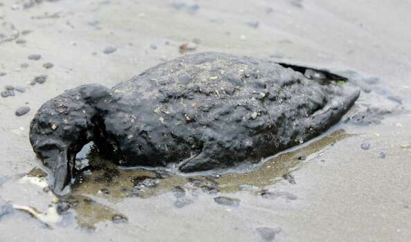
Photo By Melissa Phillip/MBO
This oil-covered bird's life ended on the shore area along Boddeker Road, on the eastern end of Galveston near the Ship Channel.
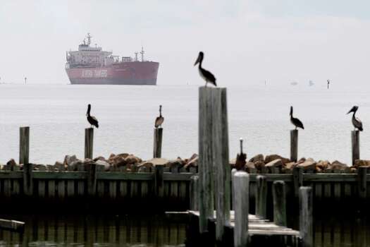
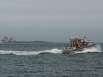
Photo By Thomas B. Shea
A tanker passed through Galveston Bay near the Shoreacres area.
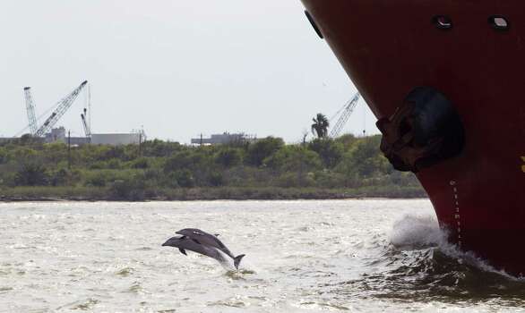
Photo By Brett Coomer/Houston Chronicle
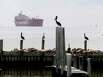
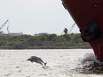
A pair of dolphins leap out of the water in front of a ship near Pelican Island in Galveston Bay Thursday, Oct. 18, 2012, in Galveston. A coal port is being planned for the island in Galveston Bay better known for flounder fishing and Seawolf submarine park. ( Brett Coomer / Houston Chronicle )
1 of 3
Galveston Bay epitomizes Texas in ways that are hard to understand for someone not from here. It represents what Texas is all about.
It has an amazing mix of uses, including recreational, commercial and industrial. Recreational uses range from fishing to boating to bird watching to surfing tanker wakes. Its commercial productivity is immense. The Bay produces more than half of Texas' bay shrimp, more than 30 percent of Texas' oysters and enough blue crab to export to places like Maryland. And its industrial and shipping complex is unrivaled.
With the nation's top port and more than 25 percent of the nation's petrochemical capacity surrounding it, the Bay is a major center of commerce in the United States. And we usually do a great job balancing all of these different aspects of the Bay. Only until an event like the March 22 "Texas City Y" oil spill occurs do you realize how fragile that balance really is.
We've learned how busy and tight the Houston Ship Channel is, with 1,000 ocean-going vessels and 11,000 service vessels traversing the Texas City Y each month. We know that Galveston has lost significant habitat over the past 60 years. More than 35,000 acres of wetlands have disappeared, primarily due to man-induced subsidence. We lost nearly 90 percent of our underwater sea grasses in West Bay during that same period. And our oyster reefs have taken a huge hit, with massive amounts of shell mined in the 1960s and 1970s for use as road-building material. More recently, Hurricane Ike damaged or destroyed more than 50 percent of the Bay's reefs.
To strengthen this fragility, we have a responsibility to invest in the Bay's health. We do this by investing in coastal restoration projects that build resiliency into our coast. If we strengthen the health of the Bay over time, it is much more likely to bounce back quickly from impacts like the March 22 spill. And despite the long-term losses mentioned, we have numerous real-world examples of successful restoration projects that are making the Bay healthier today than it was a decade ago.
Investing in the health of the Bay and the Texas coast is not simply a feel-good measure - it's an economic imperative.
In Texas alone, sales linked to commercial and recreational fishing-related activity generate $4.6 billion annually. Coastal tourism - recreational fishing, hunting and wildlife watching - supports 143,000 Texas jobs and injects $17.9 billion into the economy, more than a quarter of all travel dollars spent in Texas every year.
Funds anticipated to result from the Deepwater Horizon oil spill provide a historic opportunity to significantly invest in the health of the Texas Gulf Coast.
In 2012, Congress passed and the president signed what is now referred to as the Restore Act, which requires that 80 percent of Clean Water Act civil penalties paid by BP and other responsible parties in connection with the April 2010 Deepwater Horizon oil spill be deposited into a trust fund that will send those fines back to the Gulf Coast. Texas could receive as much as $1 billion from these penalties.
These funds are divided into different accounts with slightly different purposes, but all of which must be implemented under the larger intent and spirit of the Restore Act itself - to restore and revitalize the Gulf Coast ecosystem and economy.
The Restore Act establishes a new federal entity called the Gulf Coast Ecosystem Restoration Council, which is made up of representatives from the five Gulf Coast states and six federal agencies.
The members of the council believe that if we can restore and conserve habitat, restore water quality, replenish and protect living coastal and marine resources, and enhance community resilience, we can, in turn, restore and revitalize the Gulf Coast economy.
We firmly agree.
But Texas leaders are already publicly discussing using Restore Act funds for "infrastructure" projects that will provide no benefit to our coastal ecosystem and might actually further degrade its health. They are hearing from local communities about road and bridge projects and other nonrestoration projects to be funded with Restore Act dollars.
Decision-makers in Texas are faced with an unprecedented opportunity right now: They can stand up for Galveston Bay and the Texas coast in a way that will continue to enhance the lives of Texans for generations to come and build the coastal resiliency we need, or they can succumb to political pressure from every direction and fund projects that have nothing to do with environmental restoration and may even harm the health of Galveston Bay and the Texas coast.
We strongly urge Texas to make the right choice and use this once-in-a-lifetime opportunity to build the additional coastal resiliency for Galveston Bay and the Texas coast that we desperately need. Doing so will better position us to move past the next oil spill, which undoubtedly lies somewhere on our horizon.
The Unified Command in Port O'Connor is overcoming logistical challenges posed by the remote island in order to clean up the emigrating oil from the Texas City collision. (U.S. Coast Guard photo by Petty Officer 2nd Stephen Lehmann)
Oil spill responders from the Matagorda Incident Command Post in Port O’Connor, Texas, continued to implement their aggressive plans, Saturday, to protect environmentally sensitive Matagorda Bay against impact from a portion of the oil spilled in the ship-barge collision near Texas City, and to anticipate potential impacts further south on the Texas coast.
The Unified Command has deployed equipment on the sandy beaches of south Matagorda Island to begin cleanup operations. Task force teams will manually cleanup oil with rakes, shovels and buckets on the 24 miles of beach line from the Matagorda Island State Park.
Crews continue to position equipment and gear on the island. Logistics of transporting ATVs, gear and personnel are challenging, as the only access to the island is by vessel and barge. Crews are overcoming the logistical challenge with great emphasis on limiting environmental impact to the fragile ecosystem.
In a proactive move, the Unified Command, comprised of the Texas General Land Office, Kirby Inland Marine and U.S. Coast Guard, disseminated accurate and timely information to stakeholders in a teleconference briefing for elected local, county and state officials, emergency management coordinators, and port authorities from counties south of Matagorda Island.
Crews are removing boom and have cleared Saluria Bayou and Big Bayou along Pass Cavallo, as well as areas of Matagorda Bay. Removal of boom will continue tomorrow around Bird Island. Mariners should monitor Marine Safety Information Broadcasts issued by Coast Guard Sector Corpus Christi for updated information regarding navigation in the affected area.
Members of the public are discouraged from accessing Matagorda Island until the Unified Command announces that response operations are complete.
The Texas Department of Health tested and confirmed that samples taken yesterday in the Matagorda Bay are in fact biological in origin and are not related to the oil.
A wildlife rehabilitation facility has been established in Port O’Connor at the Texas Parks & Wildlife Coastal Fisheries Laboratory, to assist in the event that birds or marine life are impacted by the oil. Persons who observe any impacted wildlife should not attempt to capture or handle them but are urged to call 888-384-2000.
A claims number has been established for persons who may have questions in regard to personal impact by the incident. The number is 855-276-1575.
For more information, contact the Matagorda Bay joint information center at 214-225-8007.
###
For more information contact:
Texas City Y Response JIC
Unified Command
(713) 435-1505
Galveston Island Convention Center
5600 Seawall Blvd.
Galveston, TX 77554 TexasCityYResponse@gmail.com
An overflight conducted by response personnel shows oil from the Texas City collision making landfall on a remote stretch of Matagorda Island, March 28, 2014. Response crews are staging the equipment and assets necessary to expedite the clean up effort. Video by the Port O'Connor Unified Command. Available in High Definition through DVIDS.
Oil spill responders from the Matagorda Incident Command Post in Port O’Connor, Texas, continued to implement their aggressive plans to protect environmentally sensitive areas of Matagorda Bay, Friday, against impact from a portion of the oil spilled in the ship-barge collision near Texas City, and to anticipate potential impacts further south on the Texas coast.
The Unified Command has established eight 25-person task forces to accomplish its current plans. At first light tomorrow, four task forces will attack the oil which has already come ashore at Matagorda Island. Four additional task forces, three at Rockport (Cove Harbor South) and one task force at Aransas Pass, are staging to be in an effective position to promptly respond to oil impacting areas further south.
At 2:30 p.m., today a local mariner reported seeing what he believed to be small amounts of oil that have entered the areas of Big Bayou and Saluria Bayou. Two skimmers were deployed to sample the quarter-sized pieces of floating debris. Environmental scientists believe that the samples are algae and sent them to a lab for testing.
The Coast Guard advises all mariners to avoid the Saluria Bayou and Big Bayou along Pass Cavallo, as well as all areas of Matagorda Bay which have been protectively boomed, so as not to interfere with response operations and to avoid contamination of other areas. Mariners should monitor Safety Marine Information Broadcasts issued by Coast Guard Sector Corpus Christi for updated information regarding navigation in the affected area.
Members of the public are discouraged from accessing Matagorda Island until the Unified Command announces that response operations are complete.
A wildlife rehabilitation facility has been established in Port O’Connor at the Texas Parks & Wildlife Coastal Fisheries Laboratory, to assist in the event that birds or marine life are impacted by the oil. Persons who observe any impacted wildlife should not attempt to capture or handle them, but are urged to call 888-384-2000. One oiled bird has been confirmed as deceased by response personnel.
A claims number has been established for persons who may have questions in regard to personal impact by the incident. The number is 855-276-175.
For more information, contact the Matagorda Bay Joint Information Center at 214-225-8007.
###
For more information contact:
Texas City Y Response JIC
Unified Command
(713) 435-1505
Galveston Island Convention Center
5600 Seawall Blvd.
Galveston, TX 77554 TexasCityYResponse@gmail.com
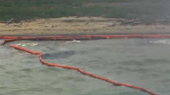
Boom is put in place to prevent oil from the Texas City collision from affecting environmentally-sensitive areas in Matagorda Bay, March 28, 2014. Approximately 150 response personnel have placed more than 16,000 feet of boom. (Unified response photo)
Oil spill responders from the Matagorda Incident Command Post in Port O’Connor, Texas, continue to implement their aggressive plans, Friday, intended to protect environmentally sensitive areas of the Matagorda Bay area against any impact from a portion of the oil spilled in Saturday’s ship-barge collision near Texas City, Texas.
Effective at 10 a.m. today, the U.S. Coast Guard has lifted the safety zone, which had been in effect for the Matagorda Ship Channel from the sea buoy to the intersection of the ship channel with the Gulf Intracoastal Waterway, permitting the resumption of normal maritime commerce in the waterway.
Mariners should remain well clear of protective booming that remains in place to protect environmentally sensitive areas of Matagorda Island and Matagorda Bay, including Sundown (Bird) Island, and Saluria Bayou and Big Bayou along Pass Cavallo. Any damage by mariners to the protective booming structure will jeopardize effective response efforts, may cause damage to private and public property and the environment, and subject the party causing the damage to prosecution under applicable law. Mariners should monitor Marine Safety Information Bulletins issued by U.S. Coast Guard Sector Corpus Christi for updated information regarding navigation in the affected area.
Members of the public are discouraged from accessing south Matagorda Island until the Unified Command announces that response operations are complete.
A wildlife rehabilitation facility has been established in Port O’Connor at the Texas Parks & Wildlife Coastal Fisheries Laboratory, to assist in the event that birds or marine life are impacted by the oil. Persons who observe any impacted wildlife should not attempt to capture or handle them, but are urged to call 888-384-2000. Two reports of affected wildlife have been received.
A claims number has been established for persons who may have questions in regard to personal impact by the incident. The number is 855-276-1575.
For more information, contact the Matagorda Bay joint information center at 214-225-8007.
###
For more information contact:
Texas City Y Response JIC
Unified Command
(713) 435-1505
Galveston Island Convention Center
5600 Seawall Blvd.
Galveston, TX 77554 TexasCityYResponse@gmail.com
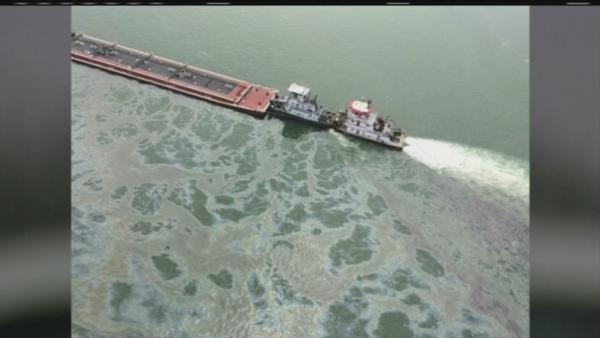
Oil makes landfall on Matagorda Island off the Texas coast, March 27, 2014. The Unified Command for the Texas City Y Response is working diligently to clean affected areas and mitigate further landfall. (Unified response photo)
Oil spill responders from the Incident Command Post Matagorda in Port O’Connor, Texas, continued to implement their aggressive plans intended to protect environmentally sensitive areas of the Matagorda Bay area against impact from a portion of the oil spilled in Saturday’s ship-barge collision near Texas City, Thursday.
The Unified Command including the U.S Coast Guard, Texas General Land Office and Kirby Inland Marine, took extensive actions yesterday in anticipation of the potential impact on those sensitive areas, based on priorities already established in the Area Contingency Plan along the coast of the Matagorda Peninsula, Matagorda Island and Sundown Island. As expected, the oil moved ashore overnight onto Matagorda Island, driven by winds and seas from the southeast.
Overflights of the area confirmed today that the oil impacted approximately 12 miles of beach on Matagorda Island, south of Matagorda Island State Park, driven ashore by rolling breakers. Protective booming across Saluria Bayou and Big Bayou appears to have been effective in preventing incursion of oil into Espiritu Santo Bay. NOAA expects that much of the oil will be stranded on the Matagorda Island beach and will employ overflight observations to forecast whether there may be future movement of any oil remaining offshore.
Approximately 150 field response personnel, utilizing 12 response vessels, worked steadily to deploy and adjust more than 16,000 feet of protective boom. They are supported by 96 personnel in the command post. In addition, responders have staged 48,600 feet of containment boom and 80,000 feet of absorbent boom.
At first light tomorrow, responders will aggressively attack the oil deposited on the Matagorda Island beach, starting with the areas of heaviest concentration at the southern end of the affected area. The evolution presents logistics challenges, since the area is only accessible by boat through the shallow waters of the inshore bays. Information from additional overflights will help direct those efforts.
Members of the public are discouraged from accessing the island until the Unified Command announces that response operations are complete.
A wildlife rehabilitation facility has been established in Port O’Connor at the Texas Parks & Wildlife Coastal Fisheries Laboratory, to assist in the event that birds or marine life are impacted by the oil. Persons who observe any impacted wildlife should not attempt to capture or handle them but are urged to call 888-384-2000. No reports of affected wildlife have been received.
A claims number has been established for persons who may have questions in regard to personal impact by the incident. The number is 855-276-1575.
For more information, contact the Matagorda Bay joint information center at 214-225-8007.
###
For more information contact:
Texas City Y Response JIC
Unified Command
(713) 435-1505
www.TexasCityYResponse.com
2010 5th Ave. N.
Texas City, TX 77590 TexasCityYResponse@gmail.com
Texas City "Y" Response - Matagorda Bay Impact; Oil projected to be pushed shoreward
FOR IMMEDIATE RELEASE
DATE: March 26, 2014 7:20:25 PM CDT
Texas City "Y" Response - Matagorda Bay Impact
Oil projected to be pushed shoreward
Potential impact estimate map created March 26, 2014, for March 27 around the Matagorda area. Click for the impact estimate map PDFs.
PORT O'CONNOR, Texas — Oil spill responders established a Matagorda Bay Forward Branch in Port O’Connor, Texas, today to coordinate protection of the environment of the Matagorda Bay area, as a portion of the oil spilled on Saturday in a ship-barge collision near Texas City, Texas, moves south along the Texas Coast.
A Unified Command including the U.S Coast Guard, Texas General Land Office and Kirby Inland Marine, the owner of the vessel from which the oil was spilled, began their response efforts today implementing aggressive plans intended to protect environmentally sensitive areas against impact from the oil, based on priorities already established in the Area Contingency Plan.
While a notable portion of the approximately 168,000 gallons of the marine fuel oil has been removed by responders in the Texas City-Galveston area, an area of floating oil approximately fifteen miles off Matagorda Island is expected to be pushing shoreward by the weather over the next 24 to 48 hours. Today’s response actions are focused on placing protective boom along the sensitive areas along the coast of Matagorda Island, including Sundown Island.
Approximately 150 response personnel, utilizing 11 response vessels, are actively working to deploy over 50,000 feet of protective boom today. In addition, responders currently have staged 40,000 feet of absorbent boom, with another 45,000 feet en route to Port O’Connor.
As access to Matagorda Island is by boat, members of the public are discouraged from accessing the island until the Unified Command announces that response operations are complete.
Wildlife Response Service, a Texas-based wildlife rehabilitation service, has also been deployed to assist in the event that birds or marine life are impacted by the oil. Persons who observe any impacted wildlife should not attempt to capture or handle them but are urged to call 888-384-2000. No reports of affected wildlife have been received.
A claims number has been established for persons who may have questions in regard to personal impact by the incident. The number is 855-276-1575.
For more information, contact the Matagorda Bay joint information center at 214-225-8007.
###
For more information contact:
Texas City Y Response JIC
Unified Command
(713) 435-1505
www.TexasCityYResponse.com
2010 5th Ave. N.
Texas City, TX 77590 TexasCityYResponse@gmail.com
Update 10: Texas City "Y" response continues; port open to all marine traffic
FOR IMMEDIATE RELEASE
DATE: March 27, 2014 8:04:20 PM CDT
Update 10: Texas City "Y" response continues; port open to all marine traffic
TEXAS CITY, Texas — The Captain of the Port of Houston/Galveston has opened the bay to all traffic Thursday after multiple cleanup assessments and input from the Texas Department of State Health Services.
A current Broadcast Notice to Mariners instructs all boaters that the safety zone remains in affect, however all restrictions are lifted except to transit using safe distance and minimum safe speeds in the vicinity of any oil spill response or salvage operations and to avoid all areas of sheening or visible oil. If any oil is sighted, boaters should report it to the National Response Center at 1-800-424-8802.
While all recreational activities, including swimming is open, the DSHS does advise people not to swim in areas where they can see oil.
The DSHS stated that there is no indication that seafood in the marketplace has been impacted by the oil spill. For more information please visit www.dshs.state.tx.us/news/updates.shtm.
After storms Wednesday afternoon and evening slowed cleanup efforts somewhat in the Ports of Texas City and Galveston because of safety concerns, responders quickly ramped up their operations during the first hours of daylight to resume cleaning contaminated areas, Thursday.
The rough weather is expected to continue to subside throughout the rest of the week, and into the weekend, allowing responders to continue cleanup efforts. Mariners are also advised as they are transiting through the port to keep a watchful eye out for protective boom and other response equipment floating in their path. If found, please report the hazard to navigation to the Coast Guard on VHF Ch. 16.
Weather conditions closed 5 of the 6 decontamination stations established for boats in the area, Wednesday evening, but all reopened as the weather calmed today. Forty vessels in total have been cleaned since Saturday’s spill, with 62 more in queue.
A vessel decontamination plan has been formulated to assist vessels that may have been impacted by oil. The sites of the stations are Pelican Cut, Galveston and Bolivar. To schedule a vessel decontamination call (832)-244-1870.
A second Incident Command Post was established in Port O’Connor, Texas, Wednesday, and are directly responding to any possible local area impact. For more information, contact the Matagorda Bay Joint Information Center at (214) 225-8007.
Volunteers are expected to begin being utilized Friday morning. 949 volunteers registered to help search the shorelines for pockets of oil, birds or other wildlife that may have been affected by the spill. These volunteers will report this information to the Unified Command, who will then send response crews with proper training and equipment.
Wildlife responders currently include experts from U.S. Fish and Wildlife and Texas Parks and Wildlife Department, and are responding with rehabilitation, husbandry and stabilization trailers staged along the Texas City Dike, Bolivar Peninsula and the Phoenix Pollution Control Facility. Responders have found 45 birds that were dead on arrival to the stabilization trailers, and they are currently rehabilitating 12 birds.
The Coast Guard investigation into the incident is ongoing.
For claims, call (855)-276-1275.
###
For more information contact:
Texas City Y Response JIC
Unified Command
(713) 435-1505
www.TexasCityYResponse.com
2010 5th Ave. N.
Texas City, TX 77590 TexasCityYResponse@gmail.com
TEXAS CITY, Texas — To clarify earlier statements released by the Galveston County Health District and the Texas Department of State, the Unified Command has amplifying details for the safety zones and expectations for recreational vessels and commercial fishermen in and around the Houston/Galveston areas.
Recreational boating and fishing is still open, however general mariners are not allowed to operate in the safety zone without permission due to portions of Galveston Bay and offshore areas experiencing floating oil. They are advised to avoid sheen or floating oil outside the safety zone if encountered and to report it.
General mariners outside the safety zones have no restrictions on their movement or activities, but please avoid sheen and floating oil and report it if encountered.
Oiled commercial fishing vessels currently anchored or moored within the safety zone must be cleared by the incident command post prior to movement. Unfouled commercial fishing vessels may transit the safety zone, however no fishing activities are permitted within the safety zone.
Deep draft vessels will continue to coordinate movement through the Vessel Traffic Service.
General mariners are required to heed the following safety zones:
Update 7: Texas City "Y" incident release; cleanup
continues
DATE: March 26, 2014 10:56:42 AM CDT
Update 7: Texas City "Y" incident response cleanup
continues
Preparation for mitigating offshore oil impacts begin
TEXAS CITY, Texas — The Coast Guard continues clean up operations in the Port
of Houston/Galveston after having authorized limited marine traffic in the
safety zone for commercial ship traffic, Tuesday.
The Port Coordination Team is prioritizing ships for transit through the
channel. Barges are being allowed to transit through the Houston Ship Channel
and on the Intracoastal Waterway, after assessment teams deemed the channel
clear.
Cleanup efforts focused heavily on the environmentally sensitive lagoon area
of East Beach Tuesday. Other areas where significant amounts of oil were
recovered include Big Reef, Pelican Island and the Texas City Dike.
Weather conditions in the Port of Houston/Galveston pushed oil 12 miles out
into the Gulf of Mexico, and into a southwesterly direction along the coast. The
Unified Command has begun preparations to prevent potential environmental impact
in the Matagorda area, as Wednesday’s weather forecast may push some of the
contaminant to the shore. Response personnel, wildlife resources and protective
equipment are being deployed out of Port Lavaca in accordance with the tactics
outlined in the Area Contingency Plan.
Air monitoring continues throughout the general area, although readings have
consistently shown no reason for health concerns.
A vessel decontamination plan has been formulated to assist vessels that may
have been impacted by oil. The sites of the stations are Pelican Cut, Galveston
and Bolivar. To schedule a vessel decontamination call (832)-244-1870.
The Galveston Bolivar ferry is running and will be operating between 7 a.m.
to 7 p.m.
Experts from U.S. Fish and Wildlife and Texas Parks and Wildlife Department
are responding with rehabilitation, husbandry and stabilization trailers staged
along the Texas City Dike, Bolivar Peninsula and the Phoenix Pollution Control
Facility.
The public is reminded to refrain from capturing any potentially affected
wildlife and is urged to contact 1-(888)-384-2000 if oiled wildlife is observed.
Reporting photos of wildlife can also be emailed to wildlife@co.galveston.tx.us.
Details from the response efforts are as follows:
- Total nonconsecutive shoreline impacted – 18.9 miles
- Recovered gallons
of oily-water – 175,098 gallons
- Recovered bags of solid waste – 1,799
bags
- Total gallons of oil evaporated – 18,480 gallons
- Natural
dispersion rate of oil – 2,100 gallons
- Total containment boom deployed –
69,268 feet
- Total containment boom staged – 253,300 feet
- Additional
containment boom ordered – 5,400 feet
- Response vessels assigned – 70
vessels
- Total personnel in the field – 940
- Total personnel in the
Incident Command Post - 324
For those interested in volunteering, a list is being developed. Please call
(713)-435-1562.
The Coast Guard investigation into the incident is ongoing.
For claims, call (855)-276-1275.
For further information or media inquires contact the Joint Information
Center in Texas City at (713)-435-1505.
###
For more information contact:
Texas City Y Response JIC
Unified Command
(713)
435-1505
www.TexasCityYResponse.com
2010 5th Ave. N.
Texas City, TX
77590 TexasCityYResponse@gmail.com
- Recovered gallons of oily-water – 175,098 gallons
*** how much is oil, and how much is water ???
- Total gallons of oil evaporated – 18,480 gallons ???
- Natural dispersion rate of oil – 2,100 gallons ???
I don't believe it...tss
Document Number: 17
Texas City "Y" Response Unified Command
FOR IMMEDIATE RELEASE
DATE: March 25, 2014 1:02:38 PM CDT
Update 6: Texas City "Y" incident response; Port of Houston authorized limited marine movement
TEXAS CITY, Texas — The Coast Guard has authorized limited marine traffic in the safety zone in the Port of Houston/Galveston for commercial ship traffic, Tuesday.
Clean up operations are still ongoing, however ships are being prioritized for transit by the Port Coordination Team. Barges are being allowed to transit through the Houston Ship Channel and on the Intracoastal Waterway, after assessment teams deemed the channel clear.
"The cleanup operations progress is to the point that there is minimal danger of contamination to the commercial maritime traffic and allowing limited transit during daylight hours," said Capt. Brian Penoyer, Captain of the Port for Houston/Galveston. "This is an important accomplishment for every person working this response."
"As a member of the Central Texas Coastal Area Committee, we're pleased to see the plans outlined and implemented from our Area Contingency Plan proven effective in protecting and minimizing the impact on our sensitive and complex system," said Rich Arnhart, Regional Director of the Texas General Land Office Oil Spill Prevention & Response Region 2.
"This afternoon's reopening of the ship channel is an important milestone and a testament to the coordination, hard work and rapid response of the Incident Command and the men and women working on the water under often difficult conditions," said Jim Guidry, the Executive Vice President for Vessel Operations with Kirby Inland Marine, LP. "But our work together is not done. Kirby Inland Marine remains committed to completing this important work and to limiting any impact on the environment and local economy."
A vessel decontamination plan has been formulated to assist vessels that may have been impacted by oil. The sites of the stations are Pelican Cut, Galveston and Bolivar. To schedule a vessel decontamination call (832)-244-1870.
The Galveston Bolivar ferry is now running and will be operating between 7 a.m. to 7 p.m.
Experts from U.S. Fish and Wildlife and Texas Parks and Wildlife Department are responding with rehabilitation, husbandry and stabilization trailers staged along the Texas City Dike, Bolivar Peninsula and the Phoenix Pollution Control Facility.
There have been 18 birds confirmed captured and 10 deceased. The public is reminded to refrain from capturing any potentially affected wildlife and is urged to contact 1-(888)-384-2000 if oiled wildlife is observed. Reporting photos of wildlife can also be emailed to wildlife@co.galveston.tx.us.
There is approximately 15.5 miles of nonconsecutive impacted shoreline.
Response personnel have collected approximately 164,892 gallons of oil-water mixture. They have also collected 852 bags of solid waste. A majority of the solid waste was collected from Big Reef, Pelican Island, East Beach and Texas City Dike. The waste products include oiled debris, oil sand mixture and snare boom.
To date, the National Oceanic and Atmospheric Administration reports evaporation of 16,800 gallons and a natural dispersion rate of 1,680 gallons of spilled fuel oil.
More than 71,000 feet of containment boom have now been deployed on waters surrounding the incident site and along sensitive shorelines in the area. An additional 232,600 feet of boom has been staged for possible deployment and another 5,400 feet ordered.
Approximately 70 response vessels are actively working to skim and recover oil with more than 539 personnel actively on-scene and another 218 responding in the incident command post.
Changing currents, winds and weather conditions have necessitated response officials to further extend oil recovery plans into the Gulf of Mexico and south along Galveston Island.
Air monitoring continues throughout the general area, although readings have consistently shown no reason for health concerns.
For those interested in volunteering, a list is being developed. Please call (713)-435-1562.
The Coast Guard investigation into the incident is ongoing.
For claims, call (855)-276-1275.
For further information or media inquires contact the Joint Information Center in Texas City at (713)-435-1505.
###
For more information contact:
Texas City Y Response JIC
Unified Command
(713) 435-1505
www.TexasCityYResponse.com
2010 5th Ave. N.
Texas City, TX 77590 TexasCityYResponse@gmail.com
Update 7: Texas City "Y" incident response cleanup continues
Preparation for mitigating offshore oil impacts begin
TEXAS CITY, Texas — The Coast Guard continues clean up operations in the Port of Houston/Galveston after having authorized limited marine traffic in the safety zone for commercial ship traffic, Tuesday.
The Port Coordination Team is prioritizing ships for transit through the channel. Barges are being allowed to transit through the Houston Ship Channel and on the Intracoastal Waterway, after assessment teams deemed the channel clear.
Cleanup efforts focused heavily on the environmentally sensitive lagoon area of East Beach Tuesday. Other areas where significant amounts of oil were recovered include Big Reef, Pelican Island and the Texas City Dike.
Weather conditions in the Port of Houston/Galveston pushed oil 12 miles out into the Gulf of Mexico, and into a southwesterly direction along the coast. The Unified Command has begun preparations to prevent potential environmental impact in the Matagorda area, as Wednesday’s weather forecast may push some of the contaminant to the shore. Response personnel, wildlife resources and protective equipment are being deployed out of Port Lavaca in accordance with the tactics outlined in the Area Contingency Plan.
Air monitoring continues throughout the general area, although readings have consistently shown no reason for health concerns.
A vessel decontamination plan has been formulated to assist vessels that may have been impacted by oil. The sites of the stations are Pelican Cut, Galveston and Bolivar. To schedule a vessel decontamination call (832)-244-1870.
The Galveston Bolivar ferry is running and will be operating between 7 a.m. to 7 p.m.
Experts from U.S. Fish and Wildlife and Texas Parks and Wildlife Department are responding with rehabilitation, husbandry and stabilization trailers staged along the Texas City Dike, Bolivar Peninsula and the Phoenix Pollution Control Facility.
The public is reminded to refrain from capturing any potentially affected wildlife and is urged to contact 1-(888)-384-2000 if oiled wildlife is observed. Reporting photos of wildlife can also be emailed to wildlife@co.galveston.tx.us.
Details from the response efforts are as follows:
- Total nonconsecutive shoreline impacted – 18.9 miles
- Recovered gallons of oily-water – 175,098 gallons
- Recovered bags of solid waste – 1,799 bags
- Total gallons of oil evaporated – 18,480 gallons
- Natural dispersion rate of oil – 2,100 gallons
- Total containment boom deployed – 69,268 feet
- Total containment boom staged – 253,300 feet
- Additional containment boom ordered – 5,400 feet
- Response vessels assigned – 70 vessels
- Total personnel in the field – 940
- Total personnel in the Incident Command Post - 324
For those interested in volunteering, a list is being developed. Please call (713)-435-1562.
The Coast Guard investigation into the incident is ongoing.
For claims, call (855)-276-1275.
For further information or media inquires contact the Joint Information Center in Texas City at (713)-435-1505.
###
For more information contact:
Texas City Y Response JIC
Unified Command
(713) 435-1505
www.TexasCityYResponse.com
2010 5th Ave. N.
Texas City, TX 77590 TexasCityYResponse@gmail.com
>>> Response personnel have collected approximately 164,892 gallons of oil-water mixture.
so, what does this mean ???
2% oil, 98 % water or what ???
tss
TUESDAY MARCH 25, 2014
Ships are coming out of the Houston Ship Channel spewing out more smoke
than 1,000 cars on the freeway, heading South to the Gulf, some cigarette
offshore power boats outback now racing, a stack is flaring off over at Bayport,
things are back to normal, oil spill must be all gone, everything is o.k. $$$
TEXAS CITY, Texas — As of this evening, the Port of Houston remains closed. The Unified Command continues to assess the situation with oil in the channel to determine when vessel traffic can resume.
There are 46 outbound vessels and 47 inbound vessels in the queue for transit in the Port of Houston. The Port of Texas City has 5 inbound and 3 outbound vessels in the queue awaiting transit. Once the channel has been determined safe to navigate, and transiting vessels will not... spread oil contaminants, a prioritization list will be established to determine the entry order of vessels.
The Galveston Bolivar ferry has been given permission to operate and will be running between 7 a.m. to 7 p.m.
Experts from U.S. Fish and Wildlife and Texas Parks and Wildlife Department are responding with rehabilitation, husbandry and stabilization trailers staged along the Texas City Dike, Bolivar Peninsula and an identified rehabilitation location. There have been seven birds confirmed captured, seven deceased, and eight verified oiled, but not captured.
The public is reminded to refrain from capturing any potentially affected wildlife and is urged to contact 1-888-384-2000 if oiled wildlife is observed. Reporting photos of wildlife can also be emailed t0 wildlife@co.galveston.tx.us.
More than 71,000 feet of containment boom have now been deployed on waters surrounding the incident site and along sensitive shorelines in the area. An additional 192,500 feet of boom has been staged for possible deployment and another 20,680 feet ordered.
Changing currents, winds and weather conditions have necessitated response officials to further extend oil recovery plans into the Gulf of Mexico and south along Galveston Island.
Approximately 27 response vessels are actively working to skim and recover oil with more than 539 personnel actively on-scene and another 218 responding in the incident command post.
Air monitoring continues throughout the general area, although readings have consistently shown no reason for health concerns.
TEXAS CITY, Texas — As of this evening, the Port
of Houston remains closed. The Unified Command continues to assess the situation
with oil in the channel to determine when vessel traffic can resume.
There are 46 outbound vessels and 47 inbound
vessels in the queue for transit in the Port of Houston. The Port of Texas City
has 5 inbound and 3 outbound vessels in the queue awaiting transit. Once the
channel has been determined safe to navigate, and transiting vessels will not
spread oil contaminants, a prioritization list will be established to determine
the entry order of vessels.
The Galveston Bolivar ferry has been given
permission to operate and will be running between 7 a.m. to 7 p.m.
Experts from U.S. Fish and Wildlife and Texas
Parks and Wildlife Department are responding with rehabilitation, husbandry and
stabilization trailers staged along the Texas City Dike, Bolivar Peninsula and
an identified rehabilitation location. There have been seven birds confirmed
captured, seven deceased, and eight verified oiled, but not captured. The public
is reminded to refrain from capturing any potentially affected wildlife and is
urged to contact 1-888-384-2000 if oiled wildlife is observed. Reporting photos
of wildlife can also be emailed to wildlife@co.galveston.tx.us.
More than 71,000 feet of containment boom have
now been deployed on waters surrounding the incident site and along sensitive
shorelines in the area. An additional 192,500 feet of boom has been staged for
possible deployment and another 20,680 feet ordered.
Changing currents, winds and weather conditions
have necessitated response officials to further extend oil recovery plans into
the Gulf of Mexico and south along Galveston Island.
Approximately 27 response vessels are actively
working to skim and recover oil with more than 539 personnel actively on-scene
and another 218 responding in the incident command post.
Air monitoring continues throughout the general
area, although readings have consistently shown no reason for health
concerns.
The Coast Guard investigation into the incident
is ongoing.
For further information or media inquires
contact the Joint Information Center in Texas City at (713)-435-1505.
For claims, call (855) 276-1275.
###
For more information contact:
Texas City Y Response JIC Unified
Command voice: (713) 435-1505 www.TexasCityYResponse.com 2010 5th Ave.
N. Texas City, TX 77590TexasCityYResponse@gmail.com
Gov. Perry Directs State Resources to Respond to Houston Ship Channel Oil Spill
Sunday, March 23, 2014 • Austin, Texas • Press Release
Gov. Rick Perry has directed all necessary state resources to assist with the cleanup of oil that has spilled into the Houston Ship Channel after a collision between vessels yesterday. The Texas Division of Emergency Management (TDEM) is ensuring the coordination of the multiple state resources responding to this incident, and the governor has been briefed by TDEM Chief Nim Kidd on the ongoing cleanup efforts.
"The State of Texas is deploying all necessary resources to respond to this situation, and will continue to do so to ensure the spill is contained and cleaned up with as little impact as possible to the environment and commerce," Gov. Perry said. "We are thankful to the responders and personnel who are working diligently to respond to this situation."
The U.S. Coast Guard is the lead agency for maritime incidents such as this, while the Texas General Land Office is the lead state agency for cleanup efforts. The responsible parties are also assisting in the response to this incident. Additional state agencies and emergency response units are working to ensure public health and safety, and to protect the surrounding environment and wildlife.
The Texas General Land Office has deployed multiple personnel to the incident site to manage the cleanup effort, and resources from the Texas Department of Transportation, Texas Department of Public Safety and Texas Parks and Wildlife Department are also assisting in this effort.
The barge has been moved to a ship yard and is no longer at the scene of the spill. The Houston Ship Channel has been closed to traffic, and the Bolivar Ferry has been suspended until the spill is contained.
TEXAS CITY, TX -- A barge that once carried some 900,000 gallons of heavy tar-like oil was cleared Sunday of its remaining contents, a day after the vessel collided with a ship in the busy Houston Ship Channel and leaked as much as a quarter of its cargo into the waterway.
Coast Guard officials said that up to 168,000 gallons were dumped and that oil from the ruptured barge had been detected 12 miles offshore in the Gulf of Mexico as of Sunday afternoon.
"This is a significant spill," Capt. Brian Penoyer, commander of the Coast Guard at Houston-Galveston, said.
But he said the emptying of the barge Sunday, a process known as lightering as contents are transferred to other vessels, was equally significant.
"The remaining risk of pollution, we've removed that," he said.
Over 380 people - "and we've ordered more," he said - plus a fleet of oil-retrieving skimmers and other vessels deploying containment booms around environmentally sensitive areas worked to mitigate the damage.
Officials said they had scattered reports of wildlife damage but no specifics. Some black tar-like globs, along with a dark line of a sticky, oily substance, could be detected along the shoreline of the Texas City dike, a 5-mile-long jetty that juts into Galveston Bay across from a tip of Galveston Island.
"That is the consistency of what the cargo looks like," Jim Guidry, executive vice president of Houston-based Kirby Inland Marine Corp., the nation's largest inland barge company and owner of the barge, said when the substance was described to him at a news conference. "We're very concerned. We're focused on cleaning up," he said.
He said the company was taking responsibility for the costs. The barge was headed to a shipyard.
The channel, one of the world's busiest waterways for moving petrochemicals, was shut for a second day Sunday. As many as 60 vessels were backed up both trying to get out and get in.
Penoyer said at least one cruise ship, initially socked in by fog Saturday, was being allowed to end its trip and return to Galveston. He said others would be handled on a case-by-case basis. Its path into Galveston would take it through a safety zone defining the oil cleanup area.
There was no timetable for a total reopening of the channel, which typically handles as many as 80 vessels daily.
The Coast Guard and National Transportation Safety Board were investigating what happened.
"It will take quite a bit of time, given the complexity of the vessels and a very busy waterway," Penoyer said.
The contents of the torn tank, equal to about 4,000 barrels, were lost or displaced into other vacant areas of the barge. Penoyer said currents, tides and wind were scattering the spill.
"Containment was never a possibility in this case," he said.
Jim Ritterbusch, president of energy consultancy Jim Ritterbusch and Associates in Chicago, said if the bottleneck of vessels in the Gulf eased in a day or so, there likely wouldn't be much impact on fuel prices. A more prolonged backup could push up prices briefly, he suggested.
Crews were skimming oil from the water and deployed some 60,000 feet of containment booms to protect environmentally sensitive areas, the Coast Guard said. The area is home to popular bird habitats, especially during the approaching migratory shorebird season.
Also closed was the Texas City dike, a popular fishing spot that goes out into the Gulf for a few miles.
Lee Rilat, 58, owns Lee's Bait and Tackle, the last store before the access road to the dike, which was blocked by a police car on a breezy, overcast Sunday. If it weren't for the spill, Rilat's business would be hopping.
"This would be the first spring deal, the first real weekend for fishing," he said.
Rilat, who's lived in the area most of his life, said ships and barges have collided before. He said he doesn't think the spill is too big of a deal.
The spill site is 700 yards offshore from the Texas City dike. A crane and several small boats could be seen at the cleanup site, and dozens of trucks were at a staging area along the beach.
The captain of the 585-foot ship, Summer Wind, reported the spill Saturday afternoon. Six crew members from the tow vessel, which was going from Texas City to Port Bolivar, Texas, were injured, the Coast Guard said.
Jim Suydam, spokesman for the Texas' General Land Office, described the type of oil the barge was carrying as "sticky, gooey, thick, tarry stuff."
Richard Gibbons, the conservation director of the Houston Audubon Society, said there is important shorebird habitat on both sides of the ship channel. One is the Bolivar Flats Shorebird Sanctuary just to the east, which Gibbons said attracts 50,000 to 70,000 shorebirds to shallow mud flats that are perfect foraging habitat.
"The timing really couldn't be much worse since we're approaching the peak shorebird migration season," Gibbons said.
He added that tens of thousands of wintering birds remain in the area.
Safety Zone in the Houston Ship Channel, March 23, 2014.
HOUSTON — Efforts to contain and recover oil spilled after a collision that occurred Saturday in the Houston Ship Channel continue with an aggressive deployment of all available response resources, Sunday.
Lightering operations to transfer remaining oil from the damaged barge are expected to be complete today. After the barges are decontaminated the damaged barge will be taken to a local shipyard for assessment and needed repairs.
The primary emphasis remains the safety of response personnel working in the area and the protection of environmentally sensitive habitats, including birds and marine life.
The Unified Command, consisting of a wide variety of federal, state and local government agencies have expanded the safety zone to include all areas between Lighted Buoy 3 and Lighted Buoy 40, to prevent other vessels from interfering with the response efforts and from inadvertently facilitating the spread of oil.
Approximately 35,000 feet of boom has been deployed in containment efforts and to mitigate the affect on the environment. The area immediately surrounding the damaged barge was quickly boomed on Saturday afternoon. The maximum capacity of the breached tank is 168,000 gallons of marine fuel oil. The amount of released product still being assessed at this time.
The Bolivar ferry continues to be closed and persons with questions regarding transportation issues may contact 409-795-2230. On going air monitoring continues to show that there is no potential harm to residents or businesses in the area.
Wildlife Response Services, a Texas-based wildlife rehabilitation service has also been deployed to assist with any impacted birds or marine life. Persons who observe any impacted wildlife are urged to call 888-384-2000. As of 10 a.m. Sunday, there have been no reports of affected marine or wildlife.
A claims number has been established for persons who may have questions in regard to personal impact by the incident. The number is 855-276-1275.
For more information contact the response joint information center at 409-978-2788.
###
Saving Lives and Guarding the Coast Since 1790. The United States Coast Guard -- Proud History. Powerful Future.
TEXAS CITY, TX (KTRK) -- A barge carrying 924,000 gallons of thick, tarry fuel oil collided Saturday with another ship in the Houston ship channel and was leaking oil, officials said.
The U.S. Coast Guard said in a statement Saturday that it received a call at about 12:30 p.m. from the captain of the 585-foot ship Summer Wind reporting its collision with a barge.
The barge was being towed from Texas City to Bolivar at the time. Kirby Inland Marine, owner of the tow vessel Miss Susan and the barge, is working with the Coast Guard and Texas General Land Office at the scene, according to the Coast Guard.
A big effort is underway right now to contain the spill. The Texas City Office of Emergency Management is calling the spill moderate, even though there's about a million gallons of oil on the barge that crashed and as much as 168,000 gallons assumed to have leaked.
"There's a reasonable amount of oil in the water," said Bruce Clawson with the Texas City OEM. "I can't tell you it's a substantial amount of oil. That's being assessed at this point."
Environmental crews, boats and oil booms miles long were brought in to the Texas City Dike for deployment.
On its Facebook page, Texas City Emergency Management said the dike and all parks on the water are closed until further notice. And the Coast Guard said that part of the Houston ship channel was closed to traffic.
Richard Gibbons, the conservation director of the Houston Audubon Society, said there is very important shorebird habitat on both sides of the Houston ship channel.
Audubon has the internationally-recognized Bolivar Flats Shorebird Sanctuary just to the east, which Gibbons said attracts 50,000 to 70,000 shorebirds to shallow mud flats that are perfect foraging habitat. He did not know how much oil had been spilled, but said authorities were aware of the sanctuaries and had practiced using containment booms in the past.
"The timing really couldn't be much worse since we're approaching the peak shorebird migration season," Gibbons said. He added that tens of thousands of wintering birds remain in the area.
The spill affected people fishing, too.
"Now the oil is coming back around the other side," said Geoff Roberts, who was out fishing Saturday.
When Roberts pulled his boat out of the water, he noticed a layer of oil caked on the side. It was on his fishing reel, too.
"They even told us don't eat any fish you catch today," said Roberts.
The big concern now is keeping more oil from the barge from seeping into the bay.
Two people on that barge were taken to the hospital after coming into contact with hydrogen sulfide -- a dangerous and highly flammable gas. Their conditions are unknown. Also unknown is the cause of the crash.
Because of the oil spill, ferry services between Galveston and Bolivar have been suspended.
Monday marks the 25th anniversary of the Exxon Valdez spill off the coast of Alaska. Suydam said that spill spurred the creation of the General Land Office's Oil Spill and Prevention Division, which is funded by a tax on imported oil that the state legislature passed after the Valdez spill. The division does extensive response planning including pre-positioned equipment along the Texas coast. The Associated Press contributed to this report.
NOW, MULTIPLY THAT TIMES THE BIG SUPER TANKERS THAT WILL BE COMING UP THE HOUSTON SH!T CHANNEL, THANKS TO THE PANAMA CANAL AND THE WIDENING AND DEEPENING OF THE CHANNEL TO 50 FEET. WHO CARES ABOUT THE LARGER WAKE AND THE DAMAGE TO THE ENVIRONEMENT THERE FROM, BUT ALSO CARRIES MORE RISK TO LARGER OIL SPILLS IN GALVESTON BAY. SEND THE DAMN PORT OF HOUSTON TO GALVESTON WHERE IT BELONGS, AND HELP SAVE GALVESTON BAY !!!
Texas City dike closed after barge and ship collide
By Anita Hassan, Jayme Fraser, Harvey Rice, Ingrid Lobet | March 22, 2014 | Updated: March 23, 2014 12:21pm
Texas City police Cpl. Mickey House mans a roadblock at the entrance of the Texas City Dike on Sunday, March 23, 2014. (Melissa Phillip / Houston Chronicle)
Photo By Melissa Phillip/Houston Chronicle
Denise Pickle, shift manager at Boyd's One Stop, talks at the bait shop that is located next to the entrance of the Texas City Dike Sunday, March 23, 2014. She said, "We survived Ike, we will survive this one." (Melissa Phillip / Houston Chronicle)
Photo By Neal Mora/Photographer
A response boat heads to the scene of a collision between a ship and barge near the Texas City Dike on Saturday.
Photo By PO3PO3 Manda Emery/AP
In this image provided by the U.S. Coast Guard a barge loaded with marine fuel oil sits partially submerged in the Houston Ship Channel, Saturday March 22, 2014. The bulk carrier Summer Wind, reported a collision between the Summer Wind and a barge, containing 924,000 gallons of fuel oil, towed by the motor vessel Miss Susan. The barge collided with a ship in Galveston Bay on Saturday, leaking an unknown amount of the fuel into the popular bird habitat as the peak of the migratory shorebird season was approaching.
Photo By PO3 Manda Emery/AP
A barge loaded with marine fuel oil sits partially submerged in the Houston Ship Channel, March 22, 2014. The bulk carrier Summer Wind, reported a collision between the Summer Wind and the barge, containing 924,000 gallons of fuel oil. The barge collided with a ship in Galveston Bay on Saturday, leaking an unknown amount of the fuel into the popular bird habitat as the peak of the migratory shorebird season was approaching.
Photo By Neal Mora/Neal Mora/The Galveston County D
NEAL MORA/Special to The Galveston County Daily News A crane works to stabilize a barge after a collision with a ship in the ship channel near the Texas City Dike on Saturday afternoon March 22, 2014. Two workers on one of the vessels were exposed to hydrogen sulfide and decontaminated by the first department at the end of the dike.
Photo By Neal Mora/Neal Mora/The Galveston County D
NEAL MORA/Special to The Galveston County Daily News A barge begins to sink after a collision with a ship in the ship channel near the Texas City Dike on Saturday afternoon March 22, 2014. Two workers on one of the vessels were exposed to hydrogen sulfide and decontaminated by the first department at the end of the dike.
Photo By Brett Coomer/Houston Chronicle
Environmental personnel drive onto the Texas City Dike with oil containment booms for oil remediation following a barge collision in the ship channel, causing an oil spill Saturday, March 22, 2014, in Houston.
Photo By Brett Coomer/Houston Chronicle
Bruce Clawson, Texas Emergency Management director, gives a news conference near the Texas City Dike following a barge collision in the ship channel, causing an oil spill Saturday, March 22, 2014, in Houston.
Photo By Brett Coomer/Houston Chronicle
Emergency personnel block the road to the Texas City Dike following a barge collision in the ship channel, causing an oil spill Saturday, March 22, 2014, in Houston.
Photo By Brett Coomer/Houston Chronicle
Emergency personnel block the road to the Texas City Dike following a barge collision in the ship channel, causing an oil spill Saturday, March 22, 2014, in Houston.
Photo By Brett Coomer/Houston Chronicle
Environmental personnel drive onto the Texas City Dike for oil remediation following a barge collision in the ship channel, causing an oil spill Saturday, March 22, 2014, in Houston.
Skimming vessels scooped up oil Sunday after more than 90,000 feet of containment boom was deployed to protect the coastline from as much as 168,000 gallons of thick shipping fuel that may have spilled into Galveston Bay after a ship and barge collided near the Texas City dike Saturday afternoon.
Marine traffic in the Houston Ship Channel from the Intracoastal Waterway to lighter buoy 32 has been suspended for the safety of the responders, authorities said. The ferry connecting Galveston Island and the Bolivar Peninsula is also suspended.
The U.S. Coast Guard said officials are closely monitoring the spill area for health-threatening hydrogen sulfide and other dangerous gases that can be emitted by the spill, Coast Guard Lt. Sam Danus said. No dangerous concentrations of gases have as yet been detected, he said.
"This is an extremely serious spill," said Capt. Brian Penoyer of the U.S. Coast Guard. "It is a persistent oil."
Officials were headed up in a helicopter Sunday morning to see the extent of the spill for the first time, said Greg Pollock, deputy commissioner of the oil spill prevention response program of the Texas General Land Office. Fog and other weather had limited the line-of-sight for platform lookouts Saturday, he said.
"We're going to get a much better picture of where the oil has been and where it is going," he said.
With better information about the location of the sheen, officials will be able to tailor their response and more accurately set a time frame for reopening the ship channel, Pollock said. He expects details of the flight to be shared at a 2 p.m. press conference.
So far the spill has not affected beaches on Galveston Island, City of Galveston spokeswoman Elizabeth Rogers said. The Beach Patrol is monitoring the beaches and the Coast Guard is keeping city officials apprised, she said.
A wildlife rehabilitation trailer from Corpus Christi is expected to arrive in Texas City Sunday afternoon for trained volunteers to work with affected animals. The trailers from the Houston office will not be available until Monday because they had been in the shop for routine maintenance when the spill occurred, Pollock said.
Bob Stokes, president of the Galveston Bay Foundation, said his group will coordinate all volunteers for the response, but noted only trained professionals will work with oil and animals. He directed anyone interested in volunteering to sign up at www.galvbay.org, primarily for clerical, construction, communication or general behind-the-scenes work.
Stokes said the potential impact of the spill on birds, both local and migratory, could be substantial because of the numerous nesting areas in the bay, particularly Bolivar Flats Shorebird Sanctuary near the collision site.
"There's a lot of bird nests right there on the beaches of Bolivar Flats," he said. "Birds would be pretty susceptible to getting oiled wings."
Tides could push the oil south toward the flats if a north wind does not stall it, he said. The area had been surrounded by containment boons, but Stokes noted they are not 100 percent effective. High winds, large waves and the probability that birds would fly past them and dive into the sheen could spread the spill beyond boons.
Crews also have laid a protective boom at the ecologically critical Big Reef at the end of Galveston Island and Little Pelican Island. They closed a tidal gate where Moses Lake connects with Galveston Bay, said Pollock.
At least one cargo tank was breached when a barge carrying 924,000 gallons of a thick fuel oil collided around 12:35 p.m. with the 585-foot Summer Wind, a Liberian flag bulk vessel built in 1995, according to authorities. That cargo tank hauled 4,000 barrels, meaning as much as 168,000 gallons of the fuel could have spilled from that compartment into the bay, Coast Guard spokesman Lt. Junior Grade Kris Kidd said.
"We're still assessing what got out and what didn't," he said.
Authorities reported a sheen of oil in the water shortly after the wreck. They identified the substance as RMG 380, a special bunker fuel oil often used in shipping that doesn't evaporate easily. Treated for exposure
Two of the six crew members on the tug were treated for exposure to fumes, according to Texas City Homeland Security Director Bruce Clawson. The product can cause skin and respiratory irritation, according to the material safety data sheet.
The tug was pulling two barges from Texas City to Bolivar at the time of the collision, officials said. Geoff Roberts, 38, who was fishing Saturday with his wife and friend, said he saw the barge after the collision, which took place in what Coast Guard officials called a common crossing between the Intracoastal Waterway and the Houston Ship Channel.
Roberts said conditions were foggy when he headed out onto the water around noon. After he launched his boat from the Texas City dike, he said the occupants of other boats coming past were shouting that there had been an accident. Found oil on boat
Later, Roberts found oil on his own 21-foot-boat, Amberjack, as well as his fishing gear. "You could see a big oil slick as far as the eye could see," he said. Kirby Inland Marine, owner of the motor vessel named Miss Susan and the barges, activated its emergency response plan and is working to help the Coast Guard and the Texas General Land Office, which are on scene.
The park at the end of the 5-mile long Texas City dike was crammed with trucks and equipment supporting efforts to raise the barge, halt the oil leak and contain the spill. It served as a staging area for the deployment of thousands of feet of orange boom. Scores of workers wearing hard hats labored to deploy the long, snaking booms to protect sensitive areas.
Several hundred yards east from the tip of the dike, an area known as the Texas City Y, hundreds of flood lights lit work barges clustered around the sunken oil barge near the intersection of the Ship Channel and the Intracoastal Waterway.
The Texas City Y is so named because it's the point where ships can turn west to enter the Port of Texas City or continue along the Ship Channel.
This is the second collision near the Texas City dike in just over a week. On March 14, a 394-foot cargo ship carrying grain collided with a barge carrying 840,000 gallons of #6 fuel oil just north of the so-called "Texas City Y." Rice spilled, but no fuel oil leaked, helping advert a "major environmental incident," Coast Guard officials said at the time.
Heading north
In that case, the barge was heading north to Houston and had just turned from the Intercoastal Canal into the Houston Ship Channel.
The largest spill in the last 20 years occurred when about 462,000 gallons of Mexican crude oil spilled near Port Arthur in January 2010. The incident occurred after an 800-foot tanker collided with a barge carrying fuel to a Beaumont Exxon refinery.
The Summer Wind's Liberian flag is among the most common flown by merchant ships, which often register with a nation based on cost and regulations rather than what would common sense would call the country of origin.
Registering with a foreign nation can "provide owners with more operating flexibility and lower operating costs," including the ability to transfer vessels between registries at will, no income taxes, no staffing requirements, no limits on where vessels can be built or repaired, and no government safety inspections, according to a 2011 report of the U.S. Department of Transportation's Maritime Administration.
The total average cost of operating a vessel with a U.S. flag - with all the fees and regulations tied to it - is 2.7 times higher than foreign-flag equivalents, according to a 2011 report of the U.S. Department of Transportation's Maritime Administration. In part, that has resulted in many more U.S.-owned vessels choosing different flags, a practice called "flying a flag of convenience." At the end of 2010, 110 commercial ships participating in international commerce flew a U.S. flag, but more than 540 other American-owned vessels registered in 31 foreign countries.
Barge and Ship Collide off Texas City oil leaking into Galveston Bay
Barge collides with ship oil leaking into Galveston Bay
Texas City Dike, park cleared after barge collides with ship
500 Texas City Dike Road Texas City TX Posted: Saturday, March 22, 2014 2:58 pm | Updated: 3:59 pm, Sat Mar 22, 2014.
By T.J. AULDS
TEXAS CITY — Emergency officials have cleared out and closed access to the Texas City Dike, the nearby hurricane protection levee and Bay Street Park after a barge carrying heavy oil collided with a ship in the Texas City Ship Channel.
The two vessels collided at about 2:30 p.m. near the end of the dike, Texas City Homeland Security director Bruce Clawson said.
The barge carrying about 22,000 gallons of bunker oil is leaking, Clawson said. It was not confirmed how much of the oil had leaked into Galveston Bay.
The barge sank, Clawson said. The ship it collided with "left the area... we don't know where the ship is," he said.
Bunker or bunker fuel is a heavy crude and highly polluting oil that is also referred to bottom of the barrel oil.
Two crew members on the barge were treated for exposure because the oil contains high amounts of hydrogen sulfide, Clawson said.
There is not a danger to the community, Clawson said.
As a precaution and to help with the oil spill cleanup, police evacuated the dike, the levee and Bay Street Park. The closures were to allow easier access to the area for crews to clean up the mess, Clawson said.
Clawson said a Texas City Fire Department HazMat team was on scene and that the U.S. Coast Guard would be taking command.
The Texas General Land Office's Oil Spill Response Team also was enroute.
The collision happened just as a kiteboarding competition was set to get under way at the Texas City levee. All of the competitors and spectators at that event were cleared out.
This is a developing story and will be updated as new information becomes available.
Got photos of the road and dike closures or of the submerged barge? Send them to newsroom@galvnews.com or post them to your Facebook or Twitter accounts and hashtag #GCDN.
Mainland Editor T.J. Aulds may be reached at 409-683-5334 or tjaulds@galvnews.com.
Oiled birds are showing up at Bolivar Flats first picture is of a heavily oiled Sanderling and second picture is of White Pelicans with oiled bellies. We walked all of the beach in Bolivar Flats and a lot of the North Jetty and found no oil there so the birds are coming in to roost already oiled. A team from the USFWS will try to capture and clean up oiled birds.


 Read more: http://www.dvidshub.net/image/1217554/national-seashore-park-oil-cleanup#.UzyBCa1dUZ0#ixzz2xlbiZwDo")
 Read more: http://www.dvidshub.net/image/1217524/national-seashore-park-oil-cleanup#.UzyBg61dUZ0#ixzz2xlc2zzlQ")
 Read more: http://www.dvidshub.net/image/1216930/national-seashore-park-oil-cleanup#.UzxEfq1dUZ0#ixzz2xkYW6LDa")

, a clinical associate professor of zoological medicine at Texas A and M University, and a consultant the Wildlife Center of Texas, and Sharon Schmalz, executive director of the Wildlife Center of Texas, perform an examination of an oiled juvenile loon at the wildlife rehabilitation center established in Port O’Connor, Texas, April 1, 2014. Kirby Inland Marine, United States Coast Guard, and Texas General Land Office utilized wildlife expertise from Texas Parks and Wildlife and U.S. Fish and Wildlife continue their vigilance in ensuring the protection of bird and marine life in areas that may be impacted by the oil spilled in a March 22 incident in the Houston Ship Channel. U.S. Coast Guard photo by Petty Officer 2nd Class George Degener. Read more: http://www.dvidshub.net/image/1213597/oiled-wildlife-rehabilitation#.Uzs1Hq1dUZ0#ixzz2xfr0aSNy")