
From: Terry S. Singeltary Sr.
Sent: Wednesday, March 16, 2016 2:33 PM
To: info@gccprd.com
Subject: re-Reminder: Join us for the GCCPRD Phase 2 Public
Meetings
re-Reminder:
Join us for the GCCPRD Phase 2 Public Meetings
The Gulf Coast Community Protection and
Recovery District (GCCPRD) will host a series of public meetings in March 2016
to encourage public participation and feedback in the Storm Surge Suppression
Study.
Following three major hurricanes, the
last of which (Hurricane Ike) was the most expensive in Texas' history, Governor
Perry issued an Executive Order creating the Governor's Commission for Disaster
Recovery and Renewal. One of the Commission's recommendations was to conduct a
study to determine how coastal communities can reduce the damage impact of
future storms. In conjunction with that recommendation, Brazoria, Chambers,
Galveston, Harris, Jefferson, and Orange Counties formed the GCCPRD as a local
government corporation. The GCCPRD is now leading the Storm Surge Suppression
Study, a technical, scientific-based effort to investigate opportunities to
alleviate the vulnerability of the upper Texas coast to storm surge and
flooding. The study is funded by the Texas General Land Office through a $3.9
million federal Housing and Urban Development Community Development Block Grant
that was awarded in September 2013. This effort is an opportunity for the GCCPRD
to work collaboratively with federal, state, local, and public and private
institutions to develop a plan that meets the needs of the region and the
nation.
On February 27, 2015, the GCCPRD
concluded the initial phase of the Storm Surge Suppression Study. Phase 1
included a series of public meetings in December 2014, allowing the public the
opportunity to provide input. Now, as the study team concludes the major
technical study that defines Phase 2, the public's continued participation and
input is encouraged. Phase 2 includes storm surge modeling, alternatives
development analysis, and a thorough assessment of mitigation options for the
entire region. During Phase 3 of the study, the GCCPRD will use these findings
to recommend a cost-effective and efficient system of flood damage reduction and
surge suppression measures to help protect the six-county
region.
Public feedback
and participation has been and will be encouraged throughout the duration of the
study. A series of public meetings will be held on the following
dates:
The findings of Phase 2 of the study
were presented at the February 23, 2016 GCCPRD board meeting, and the Phase 2 Report is available
online. A large-scale public meeting is being held in each
region of the study area. During each meeting, alternatives will be presented
and the public is invited to participate and provide feedback to further screen
and select preferred alternatives. The team is not making a recommendation for a preferred
alternative at this time. Based on
feedback received during Phase 2, the team will recommend a single conceptual
alternative for each study region in the final phase of the study in June
2016.
The materials and format will be the
same at all four meetings. Informational displays will be available for viewing,
and GCCPRD representatives will provide information and answer questions. No
formal presentation will be made. Materials will be available in English and
Spanish.
If hearing impaired or language
translation services are needed, please contact the GCCPRD consulting team at
713-868-1043 or at info@gccprd.com by March 15, 2016.
GCCPRD representatives will make every reasonable effort to accommodate these
needs.
Comments will be accepted at the
public meetings and throughout the duration of the study. All comments regarding
Phase 2 study findings should be submitted or postmarked by April 15, 2016 to be
considered in Phase 3 of the study. Written comments may be mailed to the Gulf
Coast Community Protection and Recovery District in care of Col. Christopher
Sallese at 3100 West Alabama St., Houston, Texas 77098 or emailed to info@gccprd.com.
YES
TO THE IKE DIKE!
NO
TO ANYTHING ELSE!
protect
us all, or nothing...
FROM
MAYOR GLENN ROYAL
Dear Neighbors,
Only a few are alarmed and many think a levee dividing Seabrook will never
be seriously considered, yet it has been included in a state government funded
study as an alternative design to the coastal spine concept recommended by Dr.
Bill Merrell with Texas A&M at Galveston. It is presented as the low cost
storm surge protection option that would build a sea levee alongside SH 146 from
Texas City, through Seabrook, and on toward La Porte. This would divide many of
our coastal communities in half.
This design alternative was presented in the Gulf Coast Community
Protection and Recovery District’s (GCCPRD) Storm Surge Suppression Study Phase
2 Report. The report and additional information is located at www.gccprd.com.
The GCCPRD is a local government corporation that is governed by a board of
directors comprised of the county judges of Brazoria, Chambers, Galveston,
Harris, Jefferson, and Orange counties plus three additional appointed members.
The purpose of this storm suppression study is to analyze the feasibility of
protecting our communities from storm surge and flood damages.
Proposed Central Region Alternative Design #1 (CR#1) is the coastal spine
that would extend from High Island to San Luis Pass. This design offers the
greatest protection for the entire region, including those communities along SH
146 and is the preferred alternative design in the report. The second
alternative (CR#2) would be the lowest cost option offering protection to the
City of Galveston and portions of the west side of Galveston Bay but none to the
upper portions of the bay and ship channel. CR#2 was selected as an alternative
if the Bolivar Roads gate in the CR#1 coastal spine design is not able to be
constructed for technical reasons.
Based on cost-benefits analysis, both alternatives offer value. The study
shows a benefit-to-cost ratio of 3.22 for CR#1, the coastal spine, versus 6.36
for CR#2, the SH 146 levee. However, what the 6.36 cost ratio figure doesn’t
have in its’ calculation, are the financial impacts upon the communities; the
potential for higher insurance (if even available) costs and declining property
and home values for those on the “wrong” side of the levee. Not only would CR#2
effect home and business owners, it would include city halls, schools, police
and fire stations, city drinking water facilities, and waste treatment plants.
These higher operating costs will be passed on to all residents in the form of
higher taxes and fees no matter what side of the levee you live on.
Alternative design CR#2 does not protect the Bayport maritime,
petrochemical, and storage tank industrial complex. During Hurricane Ike, cargo
containers onshore became battering rams as they floated with the surge. Without
any protection for Bayport and the large number of containers on the docks, any
possibility of adrift containers should cause great concern for the potential
environmental damage to one or more ruptured petro-chemical tanks. There is even
the possibility that a floating container could damage the levee breaking its
integrity and cause its failure.
I take this GCCPRD report and its options very seriously and believe that
you should to. The coastal spine approach of CR#1 should be supported for its
benefits to all of us over the community destroying levee design of CR#2. There
will be a high societal cost if CR#2 is selected only for its perceived better
benefit-to-cost ratio that does not include community impact costs. CR#2 is an
option that would sacrifice Seabrook and our coastal neighbors. If alternative
design CR#2 is selected, in effect what we will have is the bay extending to the
SH 146 levee inundating all properties east of SH 146.
What I ask of you is to join me in making your voice heard on this very
important matter. I believe it is the most important issue that Seabrook has
ever faced. GCCPRD is now gathering public input for the Phase 2 study. A public
meeting will be held on Tuesday, March 22, 2016 from 6:00 p.m. until 8:00 p.m.
where you can learn more and voice your opinion. The meeting will be held at the
League City Civic Center, 400 West Walker Street, League City, Texas 77573. If
you are unable to attend, you can email your comments to info@gccprd.com or via
mail to Gulf Coast Community Protection and Recovery District, c/o Col.
Christopher Sallese, 3100 West Alabama St., Houston, Texas 77098.
Sincerely, Mayor Glenn Royal City of Seabrook
GCCPRD is now gathering public input for the Phase 2 study. A public
meeting will be held on Tuesday, March 22, 2016 from 6:00 p.m. until 8:00 p.m.
where you can learn more and voice your opinion. The meeting will be held at the
League City Civic Center, 400 West Walker Street, League City, Texas 77573. If
you are unable to attend, you can email your comments to info@gccprd.com or via
mail to Gulf Coast Community Protection and Recovery District, c/o Col.
Christopher Sallese, 3100 West Alabama St., Houston, Texas 77098.
Greetings Mayor Royal and all our fine Neighbors down the shoreline in
Seabrook, Kemah, Shore Acres, La Porte, Bayview, Sunny San Leon, Bacliff,
Hillmansville, and to anyone else I might have missed that may be concerned with
our federal government hanging all of us out to dry or to drown just to save
Houston and it’s precious petro chemical complex and it’s precious ship
channel.
I kindly would like to comment on this please.
So soon some forget. New Orleans survived Hurricane Katrina, what New
Orleans did not survive was the Army Corp of Engineer and the Levee failures
there from, and it does not take a rocket scientist to know, if you build a town
in the bottom of a bowl, your going to have problems. we all have known since
Hurricanes Katrina and Ike and before, that this community needs a storm wall at
the coast to protect us all, thus, the TAMU Ike Dike was proposed to protect all
of Galveston Bay, and everyone inside of it. Since then, corporate politics have
taken the forefront, and science was sent to the rear of the bus. now it seems
that all anyone is interested in is protecting Houston and the Petro Chemical
Ship Channel, and all some of us have become is collateral damage, as those of
us living east of state highway 146 from Texas City to La Porte, and everyone
in-between. it’s been a decade since Katrina and about 7 years or so since Ike,
and here we still sit, waiting for another study, and you can see the writing on
the wall, the only thing they are waiting on is a study that only protects the
Houston Ship Channel and Houston, yet hangs everyone out to dry east of State
Hwy 146, to make way for a tourist recreational land on our old homesteads.
those plans my fine neighbors and friends are already in the drawings, and
that’s no joke. why should any of us pay to protect only the petro and chemical
plants, with something that could completely wash us away? Personally, if there
cannot be a IKE Dike that protects all of us, then I would rather have no Dike
at al, if the only other alternative was the SSPEED Rice Dike Centennial Gate at
Fred Hartman Bridge, and or the Lone Star Coastal National Recreation Area
(LSCNRA, which is the RICE DIKE in disguise, don’t take the bait). WE already
know what Houston officials are capable of doing to us during an emergency i.e.
protect their own, and they have done it to us in the past, all one has to do is
remember Hurricane Rita and that nightmare on Interstate 45, when Houston
officials got scared and evacuated everybody from Houston first, when Galveston
and the 2nd tier water front was suppose to be evacuated first. Houston could
care less about our Galveston Bay communities. Furthermore, Professor Merrell of
TAMU and who from day one, fully supported only the IKE Dike as it was
originally put forth, and agrees with the conception of what would happened to
all of us if you dam up the North end of Galveston Bay. I have personally spoken
with Professor Merrel at meetings and via emails, and unless he has changed his
mind since, he is still dead set against anything but the original Ike Dike
Proposals. If we let them our government officials, the Houston Ship Channel,
and their corporate cronies dictate to us what we need, we will never get it,
it’s all politics now. Building anything but the original Ike Dike first, like
the coastal spines, building up SH146 25 feet and closing off bayous, or the
closing of the North end of Galveston Bay under Fred Hartman Bridge, if any of
these are to start first, we will never see the light of day for any Ike Dike,
nor will our children and their children. We all may as well write our social
security numbers on our arms now, because damming up the North End of Galveston
bay, and surrounding Bayous and inlets, with the SSPEED Rice Dike proposal will
only cause tsunami’s for surrounding coastal communities. we saw that during
Hurricane Ike, without the North End of Galveston bay being dammed up. so, my
final question, if the SSPEED Rice Dike is put forth, that only protects the
Houston Ship Channel Petro Chemical complex’s, and by it’s own construction
assuredly puts all of our lives at a much higher risk that live around the
adjacent shoreline communities, and the Ike Dike which would protect us all is
tabled, will it then be Rice University, the big petro chemical oil machine, the
Port of Houston, the GLO and the Army Corp of Engineers be responsible for
killing all those that were left as collateral damage living on and around the
adjacent shore lines of Galveston Bay when the next big one hits? You cannot
blame stupid on a Hurricane.
imo, if the IKE dike is not possible, then take the money and go up to the
San Jacinto River Waste Pits Superfund Site and keep that crap from leaking more
into Galveston Bay from the North, something that is happening as we
speak.
plus, seems officials have already wrote us off the map to bring in hotels,
motels, and waterfront recreation. what is this, eminent domain by proxy, forced
intentional flooding for everyone east of SH 146 so they can build commercial
waterfront real-estate?
*** Furthermore, this proposal leaves waterfront properties and communities
east of SH- 146 vulnerable; however, it maintains the possibility of waterfront
recreation and other environmental and natural coastal features.
page 11, the building and writing off of all surrounding coastal
communities for a new recreational tourist attraction $$$
Hurricane Ike here is a view from our pier back to the garage apartment,
the garage, and the main house, the day before Hurricane Ike. video scans down
shoreline in front of your house James and Tammy, and then, about halfway
through the video, after a big wave came crashing over the top of the hill, I
went in, still well before landfall of Ike, the pier went 12 hours before Ike
made landfall, or there abouts. then the video picks of the day after. HURRICANE
IKE bonnie and terry day before and the day after IKE Bacliff 77518
HURRICANE IKE Bacliff, two days later, see a video from our neighbors yard,
looking back to our gutted out apartment ‘mother-in-laws-house’ and garage, (see
how high tide still is along Bacliff shoreline), and the big rocks in neighbors
backyard and pool.
Sunday, April 5, 2015
Proposed Lone Star Coastal National Recreation Area or Rice Dike Post
Hurricane Land Grab in Disguise or Has There Been a Ike Dike Game Change Plan ?
Tuesday, September 1, 2015
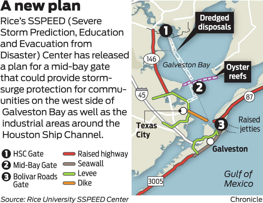
IKE DIKE 3rd PROPOSAL CALLS FOR 'MID-BAY' GATE NEAR SAN LEON ACROSS TO
SMITH POINT AREA
say no to the RICE DIKE and or any Centennial Gate across the end of
Galveston Bay at Fred Hartman Bridge, including the Lone Star Coastal National
Recreation Area (LSCNRA, which is the RICE DIKE in disguise, don’t take the
bait). ...
Thursday, November 27, 2014
IKE DIKE VS RICE DIKE PUBLIC INPUT SOUGHT PLEASE WRITE IN SUPPORT OF TAMU
IKE DIKE FOR IMMEDIATE RELEASE
Tuesday, August 5, 2014
*** Ike Dike Scientist Professor William Merrell sees NO chance of
compromise !
Monday, April 15, 2013
Hurricane Ike: 5 Years Later Conference Rice Dike Proposal September 24-25,
2013
Sunday, June 9, 2013
RICE DIKE AND IKE DIKE ARE RIVALS NO MORE, AND HAS BACKED OFF THE PROPOSAL
OF A 20-MILE 25 FOOT LEVEE ALONG SH 146
Monday, November 18, 2013
Is your community just collateral damage? RICE DIKE VS IKE DIKE
Friday, December 6, 2013
IKE DIKE TAMU VS Rice SSPEED Dike Centennial gate from Hell
October 10, 2012
IKE DIKE PROPOSED BY RICE UNIVERSITY hangs our Bayshore communities out to
dry, IN 25 FEET OF WATER, to make way for WATERFRONT RECREATION $$$
Sunday, December 9, 2012
*** RICE DIKE PROPOSAL COULD DESTROY GALVESTON BAY BAYSHORE COMMUNITIES
Hurricane Ike here is a view from our pier back to the garage apartment,
the garage, and the main house, the day before Hurricane Ike. video scans down
shoreline in front of your house James and Tammy, and then, about halfway
through the video, after a big wave came crashing over the top of the hill, I
went in, still well before landfall of Ike, the pier went 12 hours before Ike
made landfall, or there abouts. then the video picks of the day after. HURRICANE
IKE bonnie and terry day before and the day after IKE Bacliff 77518
HURRICANE IKE Bacliff, two days later, see a video from our neighbors yard,
looking back to our gutted out apartment ‘mother-in-laws-house’ and garage, (see
how high tide still is along Bacliff shoreline), and the big rocks in neighbors
backyard and pool.
Sunday, April 5, 2015
Proposed Lone Star Coastal National Recreation Area or Rice Dike Post
Hurricane Land Grab in Disguise or Has There Been a Ike Dike Game Change Plan ?
Tuesday, September 1, 2015
IKE DIKE 3rd PROPOSAL CALLS FOR 'MID-BAY' GATE NEAR SAN LEON ACROSS TO
SMITH POINT AREA
Friday, March 11, 2016
New Houston Hurricane Plan Stirs the Pot
say no to the RICE DIKE and or any Centennial Gate across the end of
Galveston Bay at Fred Hartman Bridge, including the Lone Star Coastal National
Recreation Area (LSCNRA, which is the RICE DIKE in disguise, don’t take the
bait). ...
Terry S. Singeltary Sr., Bacliff, Texas USA 77518 flounder9@verizon.net on
the bottom...