
New Houston Hurricane Plan Stirs the Pot
by Kiah Collier March 10, 2016
A new proposal to protect the Houston area from hurricanes is reigniting
controversy, and potentially diminishing the odds that a consensus will emerge
anytime soon on the best plan to safeguard the nation's fifth-largest
metropolitan area.
Since Hurricane Ike in 2008, Texas scientists have pushed several different
plans to shield the region, home to the nation's largest refining and
petrochemical complex, from devastating storm surge.
Some accord emerged in recent years around a $6 billion-to-$8 billion
Dutch-inspired concept called the “coastal spine,” creating some hope that state
and federal lawmakers may have a single proposal to champion before the next big
hurricane hits. The concept — an expanded version of another, dubbed the "Ike
Dike" — is designed to impede storm surge right at the coast with a 60-mile
seawall along Galveston Island and Bolivar Peninsula. A massive floodgate
between the two landmasses would be closed ahead of a storm. Several dozen
communities have endorsed the coastal spine — conceived at Texas A&M
University at Galveston — along with some state lawmakers, the Texas Municipal
League and at least one major industry group.
But a six-county coalition studying how best to proceed now says a 56-mile,
mostly mainland levee system — several components of which have been proposed
before by other entities — would provide a nearly equivalent level of protection
while costing several billion dollars less. The catch: several Houston-area
communities on the west side of Galveston Bay, including Kemah, La Porte,
Seabrook, Morgan’s Point and San Leon, would be left outside the dike.
And officials from those communities say that is unacceptable.
A map in the Gulf Coast Community Protection and Recovery District's latest
report shows the "coastal spine" (yellow) and a new proposal for a levee system
(purple) Enlargecredit:: The Gulf Coast Community Protection and Recovery
District (GCCPRD) A map in the Gulf Coast Community Protection and Recovery
District's latest report shows the "coastal spine" (yellow) and a new proposal
for a levee system (purple) “Just the fact that it’s mentioned — I take it as a
serious threat,” Seabrook Mayor Glenn Royal said.
The $3.5 billion proposal by the Gulf Coast Community Protection and
Recovery District, unveiled in a report last week, calls for expanding and
extending an existing levee around Texas City northward along State Highway 146
and westward to the community of Santa Fe. The recovery district's plan also
calls for placing a "ring" levee around the entire city of Galveston to protect
it from storm surge. (During hurricanes, the island gets hit by surge once from
the front and a second time from the back when surge that reaches the mainland
recedes.)
The part of the proposed levee closest to Texas City — home to three major
refineries — sits right on Galveston Bay, but most of it is set back from the
water, meaning the communities between it and the bay are left unprotected.
The U.S. Army Corps of Engineers and a hurricane research center
headquartered at Rice University also have proposed raising or building a levee
along SH-146 and installing a bayside levee to protect Galveston, but the
concepts have never gained much public support. The SH-146 proposal, in
particular, has met staunch opposition from the communities located between the
highway and the bay — a sentiment that’s not lost on the recovery district.
“It’s not the best — we know that,” said Col. Chris Sallese, coastal
programs manager at Dannenbaum Engineering, of the proposed levee system at a
Tribune event last week. The recovery district hired the local firm with a $4
million state grant to study how best to protect the greater Houston area from
hurricanes, with work beginning in 2014.
But Sallese, a former commander of the Army Corps' Galveston District, also
said there are legitimate questions about the high cost of the coastal spine and
the environmental impact of installing a massive floodgate between Galveston and
Bolivar to help keep storm surge from entering Galveston Bay. He said a big
concern is that it would greatly hinder the flow of water between the bay, one
of the region’s most productive estuaries, and the Gulf of Mexico. That could
"change the hydrodynamics, morphology, and water quality of the bay," according
to the recovery district's report.
That could mean non-compliance with federal environmental regulations such
as the National Environmental Policy Act of 1970, Sallese said. Assuming that
any storm surge protection project will be federally funded, that would mean the
project could not proceed.
Sallese said other proposals that have called for placing massive
floodgates at other places in the bay to block surge face similar environmental
concerns, so the study team wanted to propose something gate-free for the public
and recovery district board to consider and compare to the coastal spine. And
Sallese said the residents who weighed in on such a plan at a series of public
hearings last year soundly rejected the idea of installing the entire levee
system along the bay-front, which is lined with high-dollar homes and
recreational areas.
"We're not trying to take anything away from the coastal spine. We’re just
trying to say: If you could not build it, what could you do" instead, said
Sallese, noting the study team could not delve any further into environmental
impacts because of limited funding.
Asked about past opposition to SH-146 and ring levee concepts, Sallese said
no one had ever seriously examined their feasibility or cost before.
According to the recovery district's report, conducted using Army Corps
standards, the levee system would provide more than $1 billion in annual
benefits, and — at $3.5 billion — cost much less than the coastal spine, which
Sallese's team estimated would cost $5.8 billion and have about the same annual
benefit.
The levee system therefore has a cost-benefit ratio nearly twice as high as
the coastal spine, according to the report.
But Recovery District President Robert Eckels, a former Harris County
judge, stressed that the study team found that the coastal spine's cost-benefit
ratio is high, too — and that the Army Corps' cost-benefit analysis doesn't
account for social and other impacts, including economic and flood damage to
areas left outside the levee system.
The recovery district will carefully consider those other factors, he said,
going on to guess that the recovery district's final recommendation will be "a
combination of the two" plans.
Some state lawmakers have said they will champion whatever the district
recommends. And the Army Corps will use it as guidance in its own, recently
launched study into how best to protect the Texas coast from hurricanes, which
is not expected to be done for at least five years.
Army Corps Project Manager Sharon Tirpak said during a recent interview
that an environmental analysis will be a big part of the study and is what has
been missing from all the research done so far.
"None of the other entities have done any of the environmental work," she
said.
But a hybrid approach is a nonstarter for officials in bay-area communities
like Seabrook — and the researchers at Texas A&M University at Galveston
developing the coastal spine concept who believe it is end-all, be-all to the
region's hurricane problems.
"It's DOA, OK?" said Morgan's Point Mayor Michel Bechtel of the proposed
levee system, calling it "bullshit."
"It's silly to protect some of the people at the cost of the other people,"
he said. "And we will not be collateral damage, period."
Texas A&M oceanographer Bill Merrell, who conceived of the coastal
spine concept, has been opposed to placing a storm surge barrier anywhere but
directly on the coast because he says putting anything farther inland would
protect certain areas at the expense of others.
"You can’t come up with anything in the bay that doesn’t hurt somebody," he
said. "It's impossible."
Along with the bayfront communities, Merrell said the proposed levee system
leaves the western end of Galveston — lined by high-dollar beach homes important
to the island's tax base — completely unprotected. And he said it would do
nothing to block surge from entering the Houston Ship Channel, a 52-mile
shipping lane that juts off Galveston Bay. The waterway is lined with
refineries, chemical manufacturing plants and various shipping terminals whose
business activity makes up a sizable chunk of the state's GDP.
The levee system "won’t go because of public opinion," Merrell said. "The
mayors around the bay aren’t going to let this dike happen — I can assure
you."
Sallese's study team will take public comment on both the coastal spine and
levee system at a series of public meetings this month before making a
recommendation to the recovery district board, which may accept or reject it. A
final report with recommendations is expected in June.
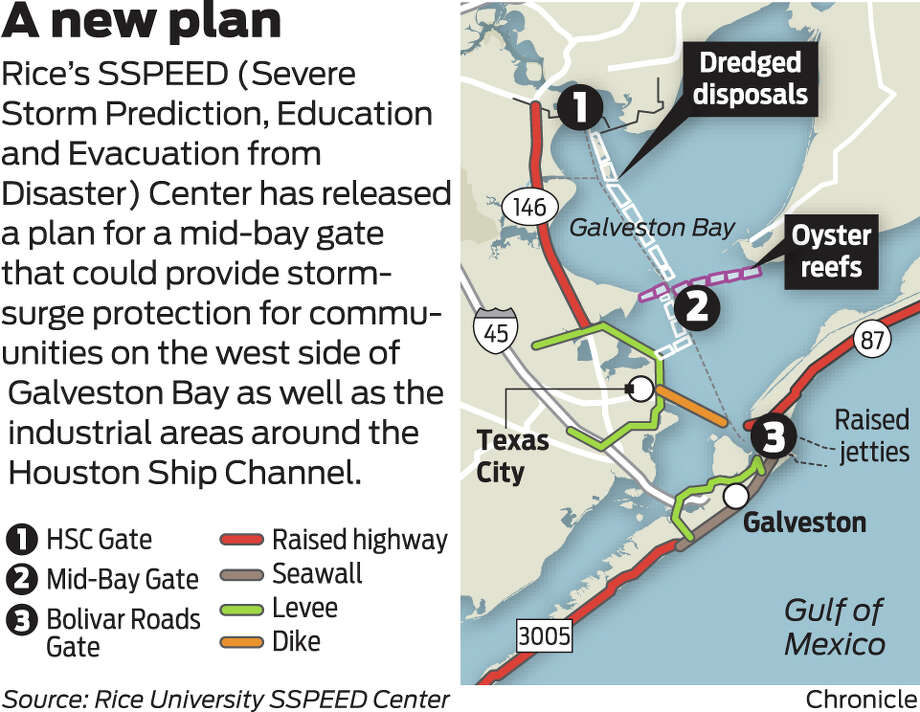
As the debate heats up, the recovery district may have an ally in the
Severe Storm Prediction, Education and Evacuation from Disasters Center at Rice,
which has pushed the SH-146 and Galveston ring levee concepts in recent
years.
Center co-director Jim Blackburn also said a combination approach would be
ideal.
"We think there is a hybrid out there that is the best of all worlds," he
said.
Blackburn's only quibble with the recovery district's report was that it
envisioned protection systems for the Houston, Beaumont and Freeport areas not
being completed until 2035.
"That’s a scary number," he said. "I think it would be failure on all of
our parts if we can’t find out how to get something underway in three to four
years — and I think that’s possible."
Disclosure: The Texas Municipal League is a corporate sponsor of The Texas
Tribune. Rice University was a sponsor in 2013. A complete list of Tribune
donors and sponsors can be viewed here.
so soon some forget. New Orleans survived Hurricane Katrina, what New
Orleans did not survive was the Army Corp of Eng. and the Levee failures there
from, and it does not take a rocket scientist to know, if you build a town in
the bottom of a bowl, your going to have problems. we all have known since
Hurricanes Katrina and Ike and before, that this community needs a storm wall at
the coast to protect us all, thus, the TAMU Ike Dike was proposed to protect all
of Galveston Bay, and everyone inside of it. Since then, corporate politics have
taken the forefront, and science was sent to the rear of the bus. now it seems
that all anyone is interested in is protecting Houston and the Petro Chemical
Ship Channel, and all some of us have become is collateral damage, as those of
us living east of state highway 146 from Texas City to La Porte, and everyone
in-between. it’s been a decade since Katrina and about 7 years or so since Ike,
and here we still sit, waiting for another study, and you can see the writing on
the wall, the only thing they are waiting on is a study that only protects the
Houston Ship channel and Houston, yet hangs everyone out to dry east of State Hwy
146, to make way for a tourist recreational land on our old homesteads. those
plans my fine neighbors and friends are already in the drawings, and that’s no
joke. why should any of us pay to protect only the petro and chemical plants,
with something that could completely wash us away? Personally, if there cannot
be a IKE Dike that protects all of us, then I would rather have no Dike at al,
if the only other alternative was the SSPEED Rice Dike Centennial Gate at Fred
Harman Bridge, and or the Lone Star Coastal National Recreation Area (LSCNRA,
which is the RICE DIKE in disguise, don’t take the bait). we all may as well
write our social security numbers on our arms now, because damming up the North
End of Galveston bay, and surrounding Bayous and inlets, with the SSPEED Rice
Dike proposal will only cause tsunami’s for surrounding coastal communities. we
saw that during Hurricane Ike, without the North End of Galveston bay being
dammed up. so, my final question, if the SSPEED Rice Dike is put forth, that
only protects the Houston Ship Channel Petro Chemical complex’s, and by it’s own
construction assuredly puts all of our lives at a much higher risk that live
around the adjacent shoreline communities, and the Ike Dike which would protect
us all is tabled, will it then be Rice University, the big petro chemical oil
machine, the Port of Houston, the GLO and the Army Corp of Eng. be responsible
for killing all those that were left as collateral damage living on and around
the adjacent shore lines of Galveston Bay when the next big one hits? You cannot
blame stupid on a Hurricane. ...
*** Furthermore, this proposal leaves waterfront properties and communities
east of SH- 146 vulnerable; however, it maintains the possibility of waterfront
recreation and other environmental and natural coastal features.
page 11, the building and writing off of all surrounding coastal
communities for a new recreational tourist attraction $$$
Thursday, November 27, 2014
IKE DIKE VS RICE DIKE PUBLIC INPUT SOUGHT PLEASE WRITE IN SUPPORT OF TAMU
IKE DIKE FOR IMMEDIATE RELEASE
Tuesday, August 5, 2014
*** Ike Dike Scientist Professor William Merrell sees NO chance of
compromise !
Monday, April 15, 2013
Hurricane Ike: 5 Years Later Conference Rice Dike Proposal September 24-25,
2013
Sunday, June 9, 2013
RICE DIKE AND IKE DIKE ARE RIVALS NO MORE, AND HAS BACKED OFF THE PROPOSAL
OF A 20-MILE 25 FOOT LEVEE ALONG SH 146
Monday, November 18, 2013
Is your community just collateral damage? RICE DIKE VS IKE DIKE
Friday, December 6, 2013
IKE DIKE TAMU VS Rice SSPEED Dike Centennial gate from Hell
October 10, 2012
IKE DIKE PROPOSED BY RICE UNIVERSITY hangs our Bayshore communities out to
dry, IN 25 FEET OF WATER, to make way for WATERFRONT RECREATION $$$
Sunday, December 9, 2012
*** RICE DIKE PROPOSAL COULD DESTROY GALVESTON BAY BAYSHORE COMMUNITIES
Hurricane Ike here is a view from our pier back to the garage apartment,
the garage, and the main house, the day before Hurricane Ike. video scans down
shoreline in front of your house James and Tammy, and then, about halfway
through the video, after a big wave came crashing over the top of the hill, I
went in, still well before landfall of Ike, the pier went 12 hours before Ike
made landfall, or there abouts. then the video picks of the day after. HURRICANE
IKE bonnie and terry day before and the day after IKE Bacliff 77518
HURRICANE IKE Bacliff, two days later, see a video from our neighbors yard,
looking back to our gutted out apartment ‘mother-in-laws-house’ and garage, (see
how high tide still is along Bacliff shoreline), and the big rocks in neighbors
backyard and pool.
Sunday, April 5, 2015
Proposed Lone Star Coastal National Recreation Area or Rice Dike Post
Hurricane Land Grab in Disguise or Has There Been a Ike Dike Game Change Plan ?
Tuesday, September 1, 2015
IKE DIKE 3rd PROPOSAL CALLS FOR 'MID-BAY' GATE NEAR SAN LEON ACROSS TO
SMITH POINT AREA
say no to the RICE DIKE and or any Centennial Gate across the end of
Galveston Bay at Fred Hartman Bridge, including the Lone Star Coastal National
Recreation Area (LSCNRA, which is the RICE DIKE in disguise, don’t take the
bait). ...
Terry S. Singeltary Sr. Bacliff, Texas USA 77518
flounder9@verizon.net
No comments:
Post a Comment